1960s Maps of Edgerton, Minnesota
Explore 4 historic maps of Edgerton from the 1960s. These maps offer a rare glimpse into what life looked like during the 1960s — showing old roads, neighborhoods, homes, and landmarks that have changed or disappeared over time.
Whether you're researching your family's past, planning a metal detecting trip, or studying how Edgerton's landscape evolved across the 1960s, these high-resolution maps are a powerful tool for exploring the history of this region.
- Focus on a specific era: All maps on this page are from the 1960s, giving you a focused view of this time period.
- See what’s changed: Compare century-old streets, trails, and buildings to today's modern landscape using overlays and satellite layers.
- Research with precision: Use these maps for genealogy, historical research, land use analysis, or educational projects.
- View, download, or print: Maps are fully viewable online in high resolution, and can be downloaded or printed for your own records.
Start exploring Edgerton's history through authentic maps from the 1960s. This is your window into the past.
Edgerton, MN maps
(4)- 1967 Map of Edgerton South, 1968 Print
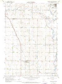 1967 Edgerton South1968 Print · USGSPipestone and Rock Counties are captured in the late sixties, showing a landscape defined by the Chicago Rock Island and Pacific railroad. Genealogists and local historians can trace the town layouts of Edgerton and Hardwick, or locate family plots at Hillside Cem.
 - 1967 Map of Edgerton North, 1968 Print
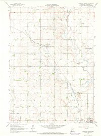 1967 Edgerton North1968 Print · USGSPipestone County in the late sixties shows a landscape defined by the Milwaukee Road and steady agricultural life. Genealogists and historians can locate Trosky Cem, the small siding at Hatfield, and numerous Gravel Pits.
 - 1967 Map of Edgerton NE, 1968 Print
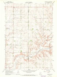 1967 Edgerton NE1968 Print · USGSSouthwestern Minnesota's prairie highlands come to life in the late sixties as agricultural townships and rail lines define the rural landscape. Researchers can locate the Woodstock Cemetery, trace the Milwaukee Road tracks, and find early landmarks like Diamond Corner.
 - 1967 Map of Kenneth, 1968 Print
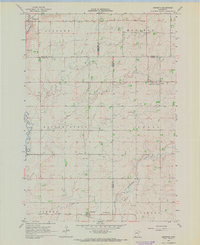 1967 Kenneth1968 Print · USGSAcross the prairie townships of southwest Minnesota in the 1960s, this survey shows the rail-and-road network connecting Kenneth and Leota. Genealogists and researchers can trace the Chicago Rock Island and Pacific rail line and locate the Leota Cem.
End of results
Showing maps 1-4 of 4
Top cities near Edgerton
- Luverne historical maps
- Pipestone historical maps
- Leota historical maps
- Chandler historical maps
- Lake Wilson historical maps
- Lismore historical maps
See more
Frequently asked questions
- What are the different types of historical maps available for Edgerton?
- What is the oldest map of Edgerton?
- Where can I purchase historical maps of Edgerton for my home or office?
- Where can I download high-res historical maps of Edgerton?
- Are there historical topographic maps available for Edgerton?
- Is there historical aerial imagery available for Edgerton?
- Where are historical maps of Edgerton sourced from?