1960s Maps of East Grand Forks, Minnesota
Explore 3 historic maps of East Grand Forks from the 1960s. These maps offer a rare glimpse into what life looked like during the 1960s — showing old roads, neighborhoods, homes, and landmarks that have changed or disappeared over time.
Whether you're researching your family's past, planning a metal detecting trip, or studying how East Grand Forks's landscape evolved across the 1960s, these high-resolution maps are a powerful tool for exploring the history of this region.
- Focus on a specific era: All maps on this page are from the 1960s, giving you a focused view of this time period.
- See what’s changed: Compare century-old streets, trails, and buildings to today's modern landscape using overlays and satellite layers.
- Research with precision: Use these maps for genealogy, historical research, land use analysis, or educational projects.
- View, download, or print: Maps are fully viewable online in high resolution, and can be downloaded or printed for your own records.
Start exploring East Grand Forks's history through authentic maps from the 1960s. This is your window into the past.
East Grand Forks, MN maps
(3)- 1963 Map of Mallory, 1964 Print
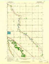 1963 Mallory1964 Print · USGSPolk County at the start of the sixties reveals a landscape of precision drainage and winding river bends. Trace the railroad community of Mallory and rural landmarks like the Pleasant View Sch or Resthaven Memorial Gardens.3 unique versions available
 - 1963 Map of Grand Forks, 1965 Print
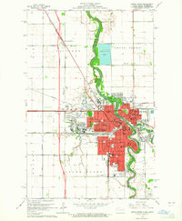 1963 Grand Forks1965 Print · USGSGrand Forks and the Red River Valley are seen here in the early 1960s as the urban footprint expanded around the university. Trace the city's growth through sites like the University of North Dakota, Calspur, and parochial schools such as St Marys Sch.2 unique versions available
 - 1966 Map of Grand Forks
 1966 Grand Forks1966 Print · USGSThe Red River Valley in the mid-sixties shows a landscape shaped by rail-line commerce and complex water management. Genealogists and historians can trace rail-side towns like Emerado and Hunter or locate rural landmarks like the Pleasant View Church.
End of results
Showing maps 1-3 of 3
Top cities near East Grand Forks
- Grand Forks historical maps
- Thompson historical maps
- Fisher historical maps
- Manvel historical maps
- Bygland historical maps
- Tabor historical maps
Frequently asked questions
- What are the different types of historical maps available for East Grand Forks?
- What is the oldest map of East Grand Forks?
- Where can I purchase historical maps of East Grand Forks for my home or office?
- Where can I download high-res historical maps of East Grand Forks?
- Are there historical topographic maps available for East Grand Forks?
- Is there historical aerial imagery available for East Grand Forks?
- Where are historical maps of East Grand Forks sourced from?