1960s Maps of Olga, Minnesota
Explore 1 historic maps of Olga from the 1960s. These maps offer a rare glimpse into what life looked like during the 1960s — showing old roads, neighborhoods, homes, and landmarks that have changed or disappeared over time.
Whether you're researching your family's past, planning a metal detecting trip, or studying how Olga's landscape evolved across the 1960s, these high-resolution maps are a powerful tool for exploring the history of this region.
- Focus on a specific era: All maps on this page are from the 1960s, giving you a focused view of this time period.
- See what’s changed: Compare century-old streets, trails, and buildings to today's modern landscape using overlays and satellite layers.
- Research with precision: Use these maps for genealogy, historical research, land use analysis, or educational projects.
- View, download, or print: Maps are fully viewable online in high resolution, and can be downloaded or printed for your own records.
Start exploring Olga's history through authentic maps from the 1960s. This is your window into the past.
Olga, MN maps
(1)- 1969 Map of Olga, 1971 Print
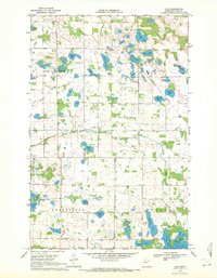 1969 Olga1971 Print · USGSPolk County land and water are meticulously detailed here in the late sixties, showcasing the intersection of agricultural townships and the Red Lake Indian Reservation Boundary. Researchers can trace rural lineages through sites like Oakland Sch, Zion Ch Cem, and the village of Olga.
End of results
Showing maps 1-1 of 1
Top cities near Olga
- Fosston historical maps
- McIntosh historical maps
- Clearbrook historical maps
- Oklee historical maps
- Gonvick historical maps
- Garnes historical maps
See more
Frequently asked questions
- What are the different types of historical maps available for Olga?
- What is the oldest map of Olga?
- Where can I purchase historical maps of Olga for my home or office?
- Where can I download high-res historical maps of Olga?
- Are there historical topographic maps available for Olga?
- Is there historical aerial imagery available for Olga?
- Where are historical maps of Olga sourced from?