1960s Maps of Sanborn, Minnesota
Explore 3 historic maps of Sanborn from the 1960s. These maps offer a rare glimpse into what life looked like during the 1960s — showing old roads, neighborhoods, homes, and landmarks that have changed or disappeared over time.
Whether you're researching your family's past, planning a metal detecting trip, or studying how Sanborn's landscape evolved across the 1960s, these high-resolution maps are a powerful tool for exploring the history of this region.
- Focus on a specific era: All maps on this page are from the 1960s, giving you a focused view of this time period.
- See what’s changed: Compare century-old streets, trails, and buildings to today's modern landscape using overlays and satellite layers.
- Research with precision: Use these maps for genealogy, historical research, land use analysis, or educational projects.
- View, download, or print: Maps are fully viewable online in high resolution, and can be downloaded or printed for your own records.
Start exploring Sanborn's history through authentic maps from the 1960s. This is your window into the past.
Sanborn, MN maps
(3)- 1967 Map of New Ulm
 1967 New Ulm1967 Print · USGSSouthern Minnesota in the mid-fifties is captured here as a landscape of river-valley missions and busy prairie rail towns. Researchers can trace the Yellow Medicine Trail and locate historic sites like the Morton Indian Mission and Milford State Monument.
 - 1967 Map of Sanborn, 1968 Print
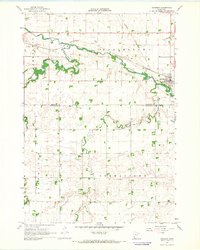 1967 Sanborn1968 Print · USGSSouthwestern Minnesota in the late sixties reveals a landscape of river-valley agriculture and rail-tied commerce. Genealogists and local historians can trace family locations near Sanborn, the Germantown Ch, and the banks of Dutch Charley Creek.
 - 1967 Map of Sanborn NE, 1968 Print
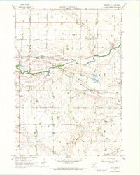 1967 Sanborn NE1968 Print · USGSSouthwestern Brown County during the late 1960s is characterized by its prairie river valleys and railroad corridors. Genealogists and historians can trace the rural infrastructure of Charlestown and Staley, including the Sanborn rail junction, Christ Ch, and the local Townhall.
End of results
Showing maps 1-3 of 3
Top cities near Sanborn
- Springfield historical maps
- Morgan historical maps
- Lamberton historical maps
- Wabasso historical maps
- Jeffers historical maps
- Comfrey historical maps
See more
Frequently asked questions
- What are the different types of historical maps available for Sanborn?
- What is the oldest map of Sanborn?
- Where can I purchase historical maps of Sanborn for my home or office?
- Where can I download high-res historical maps of Sanborn?
- Are there historical topographic maps available for Sanborn?
- Is there historical aerial imagery available for Sanborn?
- Where are historical maps of Sanborn sourced from?