1960s Maps of Sartell, Minnesota
Explore 2 historic maps of Sartell from the 1960s. These maps offer a rare glimpse into what life looked like during the 1960s — showing old roads, neighborhoods, homes, and landmarks that have changed or disappeared over time.
Whether you're researching your family's past, planning a metal detecting trip, or studying how Sartell's landscape evolved across the 1960s, these high-resolution maps are a powerful tool for exploring the history of this region.
- Focus on a specific era: All maps on this page are from the 1960s, giving you a focused view of this time period.
- See what’s changed: Compare century-old streets, trails, and buildings to today's modern landscape using overlays and satellite layers.
- Research with precision: Use these maps for genealogy, historical research, land use analysis, or educational projects.
- View, download, or print: Maps are fully viewable online in high resolution, and can be downloaded or printed for your own records.
Start exploring Sartell's history through authentic maps from the 1960s. This is your window into the past.
Sartell, MN maps
(2)- 1965 Map of St Stephen, 1966 Print
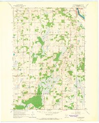 1965 St Stephen1966 Print · USGSStearns County townships like Brockway and St Wendel are shown here in the mid-sixties as the rural school system remained highly localized. Genealogists can trace family footprints near Mt Carmel Cem or identify the specific district buildings like School No 1920 and School No 1915.2 unique versions available
 - 1965 Map of St Joseph, 1967 Print
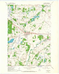 1965 St Joseph1967 Print · USGSStearns County life in the mid-1960s is centered on the railway and the river as the area transitions from rural townships to growing communities. Genealogists and historians can trace family locations near St Joseph, several rural schoolhouses, and the Staples Cem.5 unique versions available
End of results
Showing maps 1-2 of 2
Top cities near Sartell
- St. Cloud historical maps
- Saint Cloud historical maps
- Sauk Rapids historical maps
- Waite Park historical maps
- Saint Joseph historical maps
- Cold Spring historical maps
See more
Top neighborhoods of Sartell
Frequently asked questions
- What are the different types of historical maps available for Sartell?
- What is the oldest map of Sartell?
- Where can I purchase historical maps of Sartell for my home or office?
- Where can I download high-res historical maps of Sartell?
- Are there historical topographic maps available for Sartell?
- Is there historical aerial imagery available for Sartell?
- Where are historical maps of Sartell sourced from?