
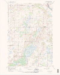
1965 Map of St Stephen
USGS Topo · Published 1966About this map
St Stephen and St Wendel anchor this mid-1960s study of the central Minnesota landscape, where the Mississippi River forms the eastern boundary of St Wendel and Brockway townships. The map reveals a densely settled rural community defined by its network of local schools, including School No 1921, School No 1984, School No 1915, School No 2063, and School No 1920, which served the farming families of the region.
Find a feature on this map
27 named features on this map. Tap any name to fly to it.
Don’t see what you’re looking for? This feature index may not catch every label — zoom into the map to look around manually.
Map Details
Editions of this 1965 St Stephen Map
2 editions found
Other maps of this area

1948 · Pierz
USGS Topo · 1:62,500

1948 · Little Falls
USGS Topo · 1:62,500

1950 · Little Falls
USGS Topo · 1:62,500

1950 · Pierz
USGS Topo · 1:62,500

1950 · St. Cloud
USGS Topo · 1:62,500

1953 · Saint Cloud
USGS Topo · 1:250,000

1957 · Saint Cloud
USGS Topo · 1:250,000

1958 · Saint Cloud
USGS Topo · 1:250,000

1965 · Holdingford
USGS Topo · 1:24,000

1965 · St Joseph
USGS Topo · 1:24,000