1900s (20th Century) Maps of Owatonna, Minnesota
Explore 8 historic maps of Owatonna from the 1900s (20th Century). These maps offer a rare glimpse into what life looked like during the 1900s — showing old roads, neighborhoods, homes, and landmarks that have changed or disappeared over time.
Whether you're researching your family's past, planning a metal detecting trip, or studying how Owatonna's landscape evolved across the 1900s, these high-resolution maps are a powerful tool for exploring the history of this region.
- Focus on a specific era: All maps on this page are from the 1900s, giving you a focused view of this time period.
- See what’s changed: Compare century-old streets, trails, and buildings to today's modern landscape using overlays and satellite layers.
- Research with precision: Use these maps for genealogy, historical research, land use analysis, or educational projects.
- View, download, or print: Maps are fully viewable online in high resolution, and can be downloaded or printed for your own records.
Start exploring Owatonna's history through authentic maps from the 1900s. This is your window into the past.
Owatonna, MN maps
(8)- 1953 Map of Saint Paul, 1964 Print
 1953 Saint Paul1964 Print · USGSThe Twin Cities and the Mississippi River valley are captured here at a mid-century turning point. Trace the early growth of Minneapolis and Saint Paul alongside landmarks like Lake Minnetonka and the St Croix River.4 unique versions available
 - 1959 Map of Saint Paul
 1959 Saint Paul1959 Print · USGSThe Twin Cities and southeastern Minnesota appear here in the late fifties, showing the peak of the rail era and post-war suburban growth. Genealogists can trace family footprints near Lake Minnetonka, the Univ Of Minn Rosemount Research Center, or the growing neighborhoods of Richfield.2 unique versions available
 - 1962 Map of Medford East, 1963 Print
 1962 Medford East1963 Print · USGSSteel County agricultural and rail life in the early sixties is centered on the busy river corridor between Medford and Clinton Falls. Genealogists and local historians can trace family locations near Perry Sch, the Rock Sch, or cemeteries like Oak Hill Cem and Eklund Cem.
 - 1962 Map of Owatonna, 1964 Print
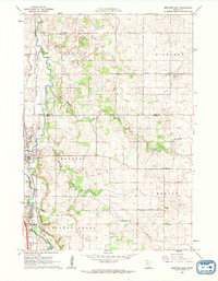
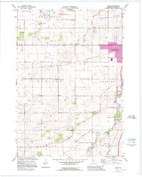
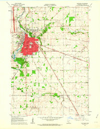 1962 Owatonna1964 Print · USGSOwatonna and the surrounding Steele County townships thrive as a major rail and educational crossroads in the early sixties. Genealogists and local historians can locate numerous rural schoolhouses and family cemeteries, including Bohemian Cemetery, Pillsbury College, and the small community of Havana.
 - 1962 Map of Saco, 1964 Print
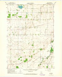 1962 Saco1964 Print · USGSSteele County at the dawn of the 1960s shows a landscape of productive farm townships and a burgeoning transportation network near Owatonna. Researchers can trace the path of the Chicago and North Western railroad or locate local landmarks like Saco, Crane Creek Sch, and the Bohemian Cem.
 - 1962 Map of Medford West, 1964 Print
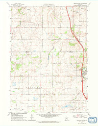 1962 Medford West1964 Print · USGSSteele and Rice Counties are captured here in the early sixties, showing the agricultural transformation of the southern Minnesota prairie. Researchers can trace the legacy of rural education and faith through sites like Sammon Sch, Trinity Cem, and the vanished Pelican Lake Bed.
 - 1985 Map of Faribault, 1986 Print
 1985 Faribault1986 Print · USGSThe Minnesota River valley and the glacial lake country of Rice and Le Sueur counties are shown here in the mid-1980s. Researchers can trace the academic grounds of St Olaf College or find old crossroads like Trondhjem and Little Chicago.2 unique versions available
 - 1991 Map of Saco, 1995 Print
 1991 Saco1995 Print · USGSSteel County farmland in the early nineties reveals a transition from traditional rural townships to modern regional centers. Genealogists can locate family burial sites at Bohemian Cem and Crane Creek Cem or trace vanished district schools like School No 2116.
End of results
Showing maps 1-8 of 8
Top cities near Owatonna
- Faribault historical maps
- Blooming Prairie historical maps
- Warsaw historical maps
- Medford historical maps
- Morristown historical maps
- Walcott historical maps
See more
Top neighborhoods of Owatonna
Frequently asked questions
- What are the different types of historical maps available for Owatonna?
- What is the oldest map of Owatonna?
- Where can I purchase historical maps of Owatonna for my home or office?
- Where can I download high-res historical maps of Owatonna?
- Are there historical topographic maps available for Owatonna?
- Is there historical aerial imagery available for Owatonna?
- Where are historical maps of Owatonna sourced from?