1980s Maps of Todd County, Minnesota
Explore 6 historic maps of Todd County from the 1980s. These maps offer a rare glimpse into what life looked like during the 1980s — showing old roads, neighborhoods, homes, and landmarks that have changed or disappeared over time.
Whether you're researching your family's past, planning a metal detecting trip, or studying how Todd County's landscape evolved across the 1980s, these high-resolution maps are a powerful tool for exploring the history of this region.
- Focus on a specific era: All maps on this page are from the 1980s, giving you a focused view of this time period.
- See what’s changed: Compare century-old streets, trails, and buildings to today's modern landscape using overlays and satellite layers.
- Research with precision: Use these maps for genealogy, historical research, land use analysis, or educational projects.
- View, download, or print: Maps are fully viewable online in high resolution, and can be downloaded or printed for your own records.
Start exploring Todd County's history through authentic maps from the 1980s. This is your window into the past.
Todd County, MN maps
(6)- 1981 Map of Lincoln, 1982 Print
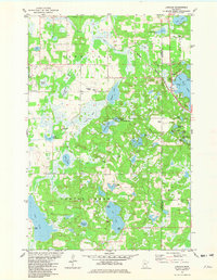 1981 Lincoln1982 Print · USGSThe lake country of Todd and Morrison Counties is shown in detail during the early 1980s, revealing a landscape of dense wetlands and fishing retreats. Local historians can trace the rail corridor of the Burlington Northern or locate the Lincoln Ch near the shores of Fish Trap Lake.
 - 1981 Map of Lake Beauty, 1982 Print
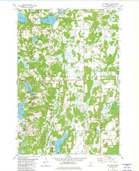 1981 Lake Beauty1982 Print · USGSIn the early eighties, this pocket of Central Minnesota shows a landscape of small townships and glacial waters. Genealogists and historians can trace the rural layout of Culdrum, locate the Zion Cem, and explore the grounds of Lake Beauty Camp.
 - 1986 Map of St. Cloud
 1986 St. Cloud1986 Print · USGSCentral Minnesota in the mid-1980s reveals a landscape where river industry and growing highway corridors meet traditional farming communities. Researchers can trace the layout of small-town landmarks like St Wendel Ch and St Anna Cem or follow the path of the Sauk River as it winds toward the Mississippi.2 unique versions available
 - 1986 Map of Brainerd
 1986 Brainerd1986 Print · USGSCentral Minnesota's lake country and river junctions are captured here in the mid-1980s. Genealogists and historians can trace the Burlington Northern line through Staples or locate family sites near Brainerd State Hospital and Gull Lake.2 unique versions available
 - 1986 Map of Lake Minnewaska
 1986 Lake Minnewaska1986 Print · USGSWest-central Minnesota's lake country is captured here in the mid-eighties, showing a landscape of intense glacial activity and growing regional hubs. Genealogists and researchers can trace the rail lines of the Soo Line and Burlington Northern through towns like Glenwood, Starbuck, and Osakis.2 unique versions available
 - 1986 Map of Battle Lake
 1986 Battle Lake1986 Print · USGSMinnesota's lake-rich glacial heartland is captured in the mid-1980s, showcasing a landscape defined by water and rail. Genealogists and collectors can trace the rural sections around Battle Lake and Parkers Prairie or locate family sites near Otter Tail Lake and Clitherall.2 unique versions available
End of results
Showing maps 1-6 of 6
Top cities of Todd County
- Long Prairie historical maps
- Little Sauk historical maps
- Browerville historical maps
- Round Prairie historical maps
- Clarissa historical maps
- Eagle Bend historical maps
See more
Frequently asked questions
- What are the different types of historical maps available for Todd County?
- What is the oldest map of Todd County?
- Where can I purchase historical maps of Todd County for my home or office?
- Where can I download high-res historical maps of Todd County?
- Are there historical topographic maps available for Todd County?
- Is there historical aerial imagery available for Todd County?
- Where are historical maps of Todd County sourced from?