1900s (20th Century) Maps of Todd County, Minnesota
Explore 39 historic maps of Todd County from the 1900s (20th Century). These maps offer a rare glimpse into what life looked like during the 1900s — showing old roads, neighborhoods, homes, and landmarks that have changed or disappeared over time.
Whether you're researching your family's past, planning a metal detecting trip, or studying how Todd County's landscape evolved across the 1900s, these high-resolution maps are a powerful tool for exploring the history of this region.
- Focus on a specific era: All maps on this page are from the 1900s, giving you a focused view of this time period.
- See what’s changed: Compare century-old streets, trails, and buildings to today's modern landscape using overlays and satellite layers.
- Research with precision: Use these maps for genealogy, historical research, land use analysis, or educational projects.
- View, download, or print: Maps are fully viewable online in high resolution, and can be downloaded or printed for your own records.
Start exploring Todd County's history through authentic maps from the 1900s. This is your window into the past.
Todd County, MN maps
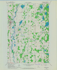
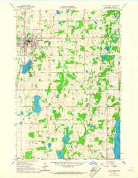
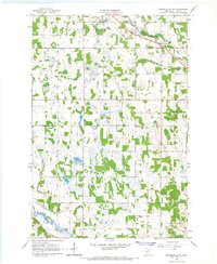
(39)- 1948 Map of Cushing, 1972 Print
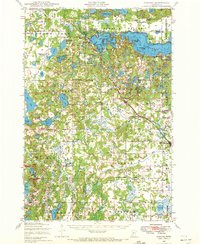 1948 Cushing1972 Print · USGSThe post-war lake country of Morrison and Todd counties comes to life in this mid-century survey, revealing a landscape of small lakeside settlements and one-room schoolhouses. Researchers can trace the roots of rural communities through dozens of local landmarks like Cushing, Betesta Church, and Willis School.2 unique versions available
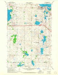
 - 1950 Map of Swanville
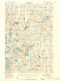 1950 Swanville1950 Print · USGSCentral Minnesota at mid-century reveals a landscape of lakeside settlements and rural school districts across the Todd and Morrison county borders. Genealogists and historians can trace family roots through sites like Spring Brook Cemetery, the Bruce Town Hall, and Lake Beauty School.2 unique versions available
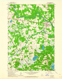
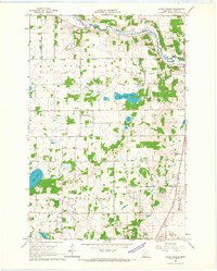
 - 1950 Map of Cushing
 1950 Cushing1950 Print · USGSMorrison and Todd counties come alive in the postwar years, showing a landscape of small farming communities and a vast network of glacial lakes. Genealogists can trace family roots through numerous rural landmarks like Randall Cemetery, Zion Church, and over twenty numbered country schools.
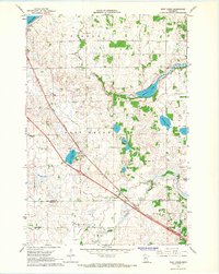
 - 1953 Map of Brainerd, 1966 Print
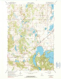
 1953 Brainerd1966 Print · USGSCentral Minnesota's lake country and iron ranges are detailed in the mid-fifties, showing the intersection of industry and wilderness. Researchers can locate specific local landmarks like the Crow Wing County Courthouse or trace the early paths of the Soo Line Railroad and the Cuyuna Range Iron Mines.3 unique versions available
 - 1953 Map of Saint Cloud, 1968 Print
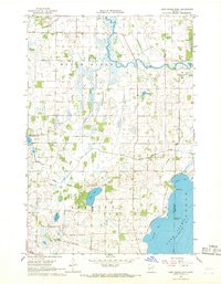
 1953 Saint Cloud1968 Print · USGSCentral Minnesota's lake country and the Mississippi River valley are caught in a period of steady mid-century growth. Researchers can trace historic rail lines, old granite works, and local landmarks like St. Johns University, Camp Ripley, and the shores of Lake Minnewaska.3 unique versions available
 - 1957 Map of Brainerd
 1957 Brainerd1957 Print · USGSNorth-central Minnesota's lake-rich landscape is captured in the mid-1950s as a crossroads of rail, river, and forest. Genealogists and historians can trace the paths of the Great Northern and Soo Line railroads through hubs like Brainerd, Wadena, and Detroit Lakes.
 - 1957 Map of Saint Cloud
 1957 Saint Cloud1957 Print · USGSCentral Minnesota's lake country and rail corridors are meticulously detailed in the mid-1950s. Genealogists and researchers can trace the growth of towns like Alexandria, Willmar, and Saint Cloud along the Great Northern railroad line.
 - 1958 Map of Saint Cloud
 1958 Saint Cloud1958 Print · USGSCentral Minnesota in the mid-1950s shows a landscape of growing regional hubs and hundreds of glacial lakes connected by an extensive rail network. Genealogists and historians can trace the early footprints of Saint Cloud, Alexandria, and Willmar along the Great Northern Railway.
 - 1958 Map of Brainerd
 1958 Brainerd1958 Print · USGSCentral Minnesota in the late fifties is a landscape of dense lake chains, rail hubs, and sprawling state forests. Genealogists and local historians can trace old property alignments near the Mississippi River or locate family sites in Brainerd, Little Falls, and Detroit Lakes.
 - 1963 Map of Motley, 1964 Print
 1963 Motley1964 Print · USGSThe confluence of the Crow Wing and Long Prairie Rivers defines this pocket of central Minnesota in the early sixties. Genealogists and local historians can trace the footprint of Motley and Philbrook, along with sites like School No 1212 and St James Cem.2 unique versions available
 - 1965 Map of Brainerd
 1965 Brainerd1965 Print · USGSNorth-central Minnesota in the mid-fifties presents a complex landscape of sprawling lake systems and established rail corridors. Genealogists and historians can trace the growth of timber towns along the Northern Pacific RR and explore early borders of the White Earth Indian Reservation or Tamarac National Wildlife Refuge.
 - 1966 Map of West Union, 1967 Print
 1966 West Union1967 Print · USGSThe West Union area was a patchwork of prairie lakes and rail-side settlements in the mid-sixties. Genealogists and local historians can trace rural school districts like School No 2331 and quiet landmarks such as Elim Ch or Silver Creek Cem.
 - 1966 Map of Browerville, 1967 Print
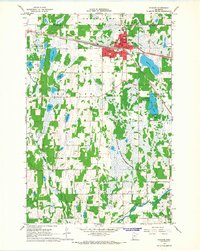
 1966 Browerville1967 Print · USGSBrowerville and the surrounding Todd County countryside are documented here in the mid-sixties as the local rail-and-river economy thrived. Researchers can trace family roots at Evergreen Cem, locate early rural schoolhouses like School No 2267, and follow the Great Northern tracks.
 - 1966 Map of Osakis, 1967 Print
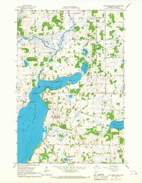
 1966 Osakis1967 Print · USGSThe lakeside community of Osakis thrived as a transportation and recreation hub in the mid-sixties. Researchers can trace the town's layout near Lake Osakis, locating St Agnes Sch, the Great Northern rail line, and numerous rural burial grounds like English Grove Cem.2 unique versions available
 - 1966 Map of Sauk Lake, 1967 Print
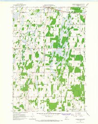
 1966 Sauk Lake1967 Print · USGSTodd County's lake-rich landscape is captured here in the mid-1960s, showing the rural communities and schools that define the region. Researchers can trace the Great Northern rail line and locate landmarks like Little Sauk Church or the Minnesota Home School.
 - 1966 Map of Browerville NE, 1967 Print
 1966 Browerville NE1967 Print · USGSIn the mid-1960s, this portion of Todd County remained a landscape of prairie rivers and small-town school districts. Researchers can find old landmarks like St Isidore Ch, School No 2286, and the Moran-Riverside Cem tucked along the Long Prairie River.
 - 1966 Map of Long Prairie, 1967 Print
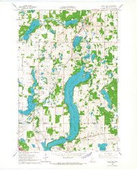
 1966 Long Prairie1967 Print · USGSLong Prairie and its glacial lake country are captured here in the mid-sixties, showing a landscape defined by the Great Northern rail and family farms. Trace local history at Lutheran Cem, School No 2268, or along the banks of Latimer Lake.2 unique versions available
 - 1966 Map of Lake Osakis East, 1967 Print
 1966 Lake Osakis East1967 Print · USGSCentral Minnesota's lake country is captured here in the mid-sixties, showing the rural townships of Todd County during a period of steady agricultural life. Genealogists can locate family landmarks such as Stallcop Cem, School No 2347, and the Leslie Ch nestled between Lake Osakis and Maple Lake.
 - 1966 Map of Staples, 1967 Print
 1966 Staples1967 Print · USGSMid-century Staples thrives as a railroad and educational center on the Todd County line during the late sixties. Genealogists can locate family landmarks from the Evergreen Cemetery to rural schoolhouses like Riverside School and School No 2289.
 - 1966 Map of Clarissa, 1967 Print
 1966 Clarissa1967 Print · USGSTodd County farm country comes to life in the mid-sixties, centered on the rail-linked village of Clarissa. Genealogists and local historians can locate rural landmarks including School No 2365, Zoar Cem, and the Great Northern railroad tracks.
 - 1966 Map of Browerville SW, 1967 Print
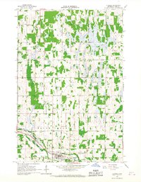
 1966 Browerville SW1967 Print · USGSTodd County farm country and wetlands are captured here in the mid-sixties as small-town life centered on the Great Northern rail line. Researchers can locate several rural landmarks including Evergreen Cem, School No 2321, and the Clarissa Municipal Airfield.
 - 1966 Map of Round Prairie, 1967 Print
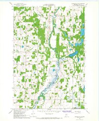
 1966 Round Prairie1967 Print · USGSTodd County farm and lake country comes into focus in the mid-1960s, showing a landscape shaped by the railroad and the river. Researchers can locate family landmarks like Reynolds Ch, the Reynolds Cem, and the old station at Round Prairie.
 - 1966 Map of Ward Springs, 1968 Print
 1966 Ward Springs1968 Print · USGSCentral Minnesota lake country is captured here in the 1960s as a landscape of small villages and lakeside woods. Genealogists and local historians can trace the Northern Pacific rail line through Ward Springs, Spaulding, and Grey Eagle.
 - 1966 Map of Lake Osakis West, 1968 Print
 1966 Lake Osakis West1968 Print · USGSDouglas County’s lake-rich landscape is captured here in the mid-sixties, showcasing the expansive northern shores of Lake Osakis. Genealogists and historians can trace the Great Northern rail line and locate landmarks like Pahlun Ch or Yates Point.2 unique versions available
 - 1966 Map of Aldrich South, 1968 Print
 1966 Aldrich South1968 Print · USGSTodd and Wadena Counties are captured here in the mid-1960s, showing a landscape of river-bottom wetlands and structured township grids. Genealogists and local historians can locate rural landmarks like Balsamlund Ch, the Maple Leaf Sch, and the Northern Pacific line through Aldrich.
Showing maps 1-25 of 39
Top cities of Todd County
- Long Prairie historical maps
- Little Sauk historical maps
- Browerville historical maps
- Round Prairie historical maps
- Clarissa historical maps
- Eagle Bend historical maps
See more
Frequently asked questions
- What are the different types of historical maps available for Todd County?
- What is the oldest map of Todd County?
- Where can I purchase historical maps of Todd County for my home or office?
- Where can I download high-res historical maps of Todd County?
- Are there historical topographic maps available for Todd County?
- Is there historical aerial imagery available for Todd County?
- Where are historical maps of Todd County sourced from?