
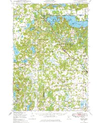
1948 Map of Cushing
USGS Topo · Published 1972About this map
Lake Alexander dominates the northern landscape of this central Minnesota region, dotted with numerous islands such as Kanzas Island and Big Island. This 1948 survey shows a rural economy organized around small settlements like Cushing and Lincoln, connected by the Burlington Northern railroad corridor. The dense network of over twenty numbered schoolhouses, including School No 137 and School No 20, highlights the era's decentralized education system before the widespread consolidation of rural districts. Local governance and social life are anchored at the Scandia Valley Town Hall and the Parker Town Hall. Genealogists will find significant value in the distribution of regional burial sites, from the Scandia Valley Cemetery near Ham Lake to the Parker Township Cemetery and Randall Cemetery further south, mapping the ancestral footprint of the Scandia Valley and Parker townships.
Find a feature on this map
111 named features on this map. Tap any name to fly to it.
Don’t see what you’re looking for? This feature index may not catch every label — zoom into the map to look around manually.
Map Details
Editions of this 1948 Cushing Map
2 editions found
Other maps of this area

1916 · Pillager
USGS Topo · 1:62,500

1919 · Pillager
USGS Topo · 1:62,500

1947 · Flensburg
USGS Topo · 1:25,000

1948 · Belle Prairie
USGS Topo · 1:62,500

1948 · Little Falls
USGS Topo · 1:62,500

1950 · Swanville
USGS Topo · 1:62,500

1950 · Belle Prairie
USGS Topo · 1:62,500

1950 · Little Falls
USGS Topo · 1:62,500

1950 · Cushing
USGS Topo · 1:62,500

1951 · Flensburg
USGS Topo · 1:25,000