1950s Maps of Washington County, Minnesota
Explore 24 historic maps of Washington County from the 1950s. These maps offer a rare glimpse into what life looked like during the 1950s — showing old roads, neighborhoods, homes, and landmarks that have changed or disappeared over time.
Whether you're researching your family's past, planning a metal detecting trip, or studying how Washington County's landscape evolved across the 1950s, these high-resolution maps are a powerful tool for exploring the history of this region.
- Focus on a specific era: All maps on this page are from the 1950s, giving you a focused view of this time period.
- See what’s changed: Compare century-old streets, trails, and buildings to today's modern landscape using overlays and satellite layers.
- Research with precision: Use these maps for genealogy, historical research, land use analysis, or educational projects.
- View, download, or print: Maps are fully viewable online in high resolution, and can be downloaded or printed for your own records.
Start exploring Washington County's history through authentic maps from the 1950s. This is your window into the past.
Washington County, MN maps
(24)- 1950 Map of Lake Elmo
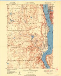
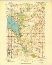
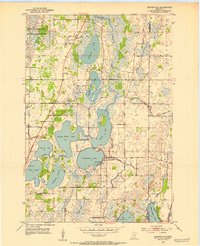
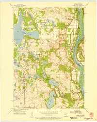
 1950 Lake Elmo1950 Print · USGSThe townships of Oakdale and Woodbury are captured in the mid-fifties, showing a landscape of small lakes and rural schoolhouses. Genealogists can trace family roots at Union Cem or locate historic school sites like Gillie Sch and Salem Sch.2 unique versions available
 - 1950 Map of Hudson
 1950 Hudson1950 Print · USGSThe St. Croix River valley at mid-century shows a network of thriving riverfront towns and rural school districts along the Minnesota-Wisconsin border. Researchers can trace the footprints of old schools like Ellmann Sch and Rentz Sch or locate the Toll Bridge connecting these two states.2 unique versions available
 - 1950 Map of St Paul Park, 1962 Print
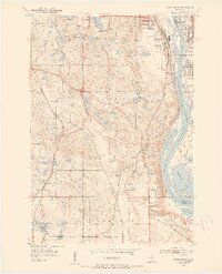
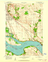 1950 St Paul Park1962 Print · USGSThe Mississippi River valley south of St. Paul is captured here at mid-century, showing the rail-dependent corridor between Newport and Nininger. Researchers can trace the legacy of local families through the Cottage Grove Cem and Sunny Hill Sch.
 - 1951 Map of St Paul Park
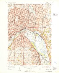
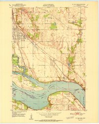 1951 St Paul Park1951 Print · USGSSoutheast of the Twin Cities in the early 1950s, the river and rail lines dictated the growth of towns along the Mississippi. Researchers can trace family sites at Grey Cloud Cem, follow the rail junction at Langdon, or locate the historic riverfront settlement of Nininger.2 unique versions available
 - 1951 Map of Prescott
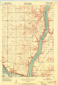 1951 Prescott1951 Print · USGSThe river confluence at the Minnesota-Wisconsin border in the early fifties shows a landscape of busy waterways and rural school districts. Genealogists can locate family landmarks like the Johnson Cem and Barkley Sch near the Kinnickinnic River bluffs.4 unique versions available
 - 1951 Map of White Bear Lake East, 1952 Print
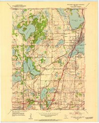
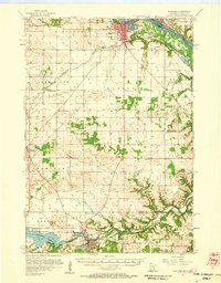
 1951 White Bear Lake East1952 Print · USGSThe lakeside communities of Washington County are shown at a point of significant growth in the early fifties. Genealogists and local historians can trace the early footprints of Mahtomedi, locate rural landmarks like Castle Sch, or identify the original site of the White Bear Airport.3 unique versions available
 - 1951 Map of Stillwater, 1952 Print
 1951 Stillwater1952 Print · USGSStillwater and the St. Croix River valley are captured in the early fifties, showcasing the area's transition from an industrial river hub to a modern regional center. Genealogists and historians can trace family roots through sites like the Minnesota State Prison, St Johns Ch, and the Boutwell Cem.4 unique versions available
 - 1951 Map of Inver Grove, 1953 Print
 1951 Inver Grove1953 Print · USGSThe Mississippi River valley south of St. Paul is documented here just as the post-war era began reshaping the Dakota County countryside. Researchers can trace the legacy of local education and faith at Rosemount Sch, St Patrick Cem, and the historic Pine Bend settlement.3 unique versions available
 - 1951 Map of St. Paul East, 1953 Print
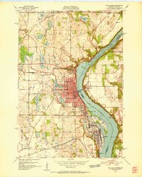
 1951 St. Paul East1953 Print · USGSSaint Paul during the early fifties reveals a thriving river-and-rail hub anchored by the State Capitol and a dense network of neighborhoods. Researchers can trace the mid-century city layout, from institutional landmarks like Gillette State Hospital to the industrial Stock Yards and Holman Airport.2 unique versions available
 - 1951 Map of St. Paul, 1959 Print
 1951 St. Paul1959 Print · USGSThe Twin Cities region during the post-war boom shows the rapid growth of St Paul and Minneapolis toward their southern suburbs. Genealogists and historians can trace numerous rural landmarks like School No 73, Roselawn Cemetery, and the St Johns Cem before suburban sprawl fully arrived.2 unique versions available
 - 1952 Map of Centerville, 1954 Print
 1952 Centerville1954 Print · USGSCenterville and the surrounding lake country of Anoka County are shown here in the early fifties, before suburban expansion reached these wetlands. Researchers can trace early rural life through landmarks like Rice Lake Ch, the Twitchel Cem, and a lakeside Seaplane Base.
 - 1952 Map of White Bear Lake West, 1954 Print
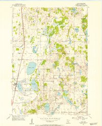
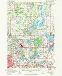
 1952 White Bear Lake West1954 Print · USGSRamsey County in the early fifties shows a landscape of expansive lakefronts and emerging suburbs before the peak of mid-century sprawl. Genealogists can trace early landmarks like Little Canada and Bethany Cem, or follow old rail lines through Cardigan Junction.3 unique versions available
 - 1953 Map of Saint Paul, 1964 Print
 1953 Saint Paul1964 Print · USGSThe Twin Cities and the Mississippi River valley are captured here at a mid-century turning point. Trace the early growth of Minneapolis and Saint Paul alongside landmarks like Lake Minnetonka and the St Croix River.4 unique versions available
 - 1953 Map of Stillwater, 1980 Print
 1953 Stillwater1980 Print · USGSThe Twin Cities and the St. Croix Valley are captured in this mid-century survey as the interstate era began to transform the Upper Midwest. Genealogists and historians can trace the rail-and-river geography of Stillwater, locate landmarks in Anoka, or explore the sprawling St Croix State Park.
 - 1954 Map of Hugo, 1956 Print
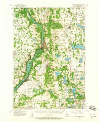
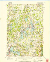
 1954 Hugo1956 Print · USGSHugo and the surrounding townships of Washington County are shown here in the mid-fifties, dominated by small lakes and the Northern Pacific rail line. Genealogists can trace rural life through numerous legacy sites like St Johns Cem and old schoolhouses including Kenyon Sch and Lynch Sch.2 unique versions available
 - 1955 Map of St. Croix Dalles
 1955 St. Croix Dalles1955 Print · USGSThe river valley along the Wisconsin and Minnesota border thrived in the mid-fifties as a hub of rail traffic and early Cold War defense. You can trace the Minneapolis St Paul and Sault Ste Marie rail lines and locate the Osceola Air Force Station or the abandoned Ubet Sch.4 unique versions available
 - 1955 Map of Marine, 1956 Print
 1955 Marine1956 Print · USGSThe St. Croix River valley in the mid-1950s shows a landscape of small settlements and glacial lakes just as outdoor recreation was expanding. Genealogists can trace family connections at Otisville and Copas, or locate vanished landmarks like the Square Lake Sch (Abandoned).
 - 1955 Map of Forest Lake, 1957 Print
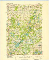
 1955 Forest Lake1957 Print · USGSChisago County's lake country is captured in the mid-fifties, showing the rail-linked towns of Lindstrom and Center City. Genealogists can find the Goose Lake School, Glader Cemetery, and the abandoned Meadow View School.3 unique versions available
 - 1955 Map of Isanti, 1957 Print
 1955 Isanti1957 Print · USGSNorth of the Twin Cities in the mid-fifties, this area reveals a dense landscape of wetlands and small rural communities. Genealogists can locate numerous pioneer sites, including Old Bethel Cem, West Bethel Ch, and several already-closed schools like Crooked Brook Sch.2 unique versions available
 - 1955 Map of New Brighton, 1959 Print
 1955 New Brighton1959 Print · USGSThe northern reaches of the Twin Cities were undergoing a post-war transformation in the mid-fifties as suburbs pushed into the lake country. Researchers can trace the massive Twin Cities Arsenal, find the old Red Brick Sch, and locate the Abandoned Aqueduct winding toward the city.
 - 1955 Map of Stillwater, 1965 Print
 1955 Stillwater1965 Print · USGSThe Upper St. Croix Valley and the growing Twin Cities area are shown here during the mid-fifties, before the interstate era transformed the regional commute. You can trace the lines of the Northern Pacific RR through towns like Rush City or locate the Saint Croix Indian Reservation.
 - 1957 Map of Hastings, 1959 Print
 1957 Hastings1959 Print · USGSDakota County and the Mississippi riverfront appear in the late fifties as a hub of rail transit and agricultural industry. Genealogists and researchers can locate landmarks like St Lukes Cem, the Mineral Springs Sanatorium, and the tracks of the Chicago Great Western.2 unique versions available
 - 1958 Map of Stillwater
 1958 Stillwater1958 Print · USGSThe Upper Mississippi and St. Croix River valleys appear in the mid-fifties as the Twin Cities expanded north. Genealogists can locate family landmarks like Oak Park Cem, Saint Michael Church, and the Soo Line RR rail corridors.2 unique versions available
 - 1959 Map of Saint Paul
 1959 Saint Paul1959 Print · USGSThe Twin Cities and southeastern Minnesota appear here in the late fifties, showing the peak of the rail era and post-war suburban growth. Genealogists can trace family footprints near Lake Minnetonka, the Univ Of Minn Rosemount Research Center, or the growing neighborhoods of Richfield.2 unique versions available
End of results
Showing maps 1-24 of 24
Top cities of Washington County
- Woodbury historical maps
- Cottage Grove historical maps
- Stillwater historical maps
- Hugo historical maps
- Mahtomedi historical maps
- Lake Elmo historical maps
See more
Frequently asked questions
- What are the different types of historical maps available for Washington County?
- What is the oldest map of Washington County?
- Where can I purchase historical maps of Washington County for my home or office?
- Where can I download high-res historical maps of Washington County?
- Are there historical topographic maps available for Washington County?
- Is there historical aerial imagery available for Washington County?
- Where are historical maps of Washington County sourced from?