Old Maps of Washington County, Minnesota for Genealogy
Trace your family roots with 139 historic maps of Washington County. These high-res maps reveal old neighborhoods, homesites, landmarks, and streets — helping you uncover where your ancestors lived and how the area evolved over time.
- Explore historic neighborhoods: Identify where your relatives may have lived in the 1800s or 1900s.
- Compare maps over time: Trace the changes in streets, buildings, and landmarks for multi-generational research.
- Perfect for genealogy & ancestry research: Used by family historians and researchers to map out lineage and migration.
These maps are an incredible resource for exploring your personal connection to Washington County's past.
Washington County, MN maps
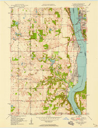
(139)- 1896 Map of St. Paul
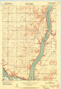
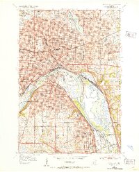
 1896 St. Paul1896 Print · USGSSt. Paul and the surrounding river townships are captured in the mid-1890s during a period of massive railroad and urban expansion. Genealogists and historians can trace the early footprints of Mendota, South St. Paul, and St. Anthony Park along with the grounds of Fort Snelling.11 unique versions available
 - 1900 Map of St Croix Dalles
 1900 St Croix Dalles1900 Print · USGSThe river gorge at the Wisconsin-Minnesota border comes alive in this late nineteenth-century survey, showing the twin hubs of the Dalles before modern expansion. Genealogists can trace family roots in Dresser Junction, El Salem, and the scattered lakefront farms of Farmington.
 - 1901 Map of St Croix Dalles
 1901 St Croix Dalles1901 Print · USGSThe river-border between Wisconsin and Minnesota was a hub of rail activity and river commerce at the start of the twentieth century. Genealogists and rail historians can trace the paths of the St. Paul and Duluth R. R. through Shafer and Taylors Falls, or locate old settlements like Franconia Station and Dresser Junction.6 unique versions available
 - 1902 Map of White Bear
 1902 White Bear1902 Print · USGSThe lake-dotted landscape northeast of the Twin Cities is captured here at the start of the twentieth century. Researchers can trace early railroad junctions and industry at the Minneapolis Stock Yards, or locate old settlements like Lino, Cardigan, and New Brighton.4 unique versions available
 - 1946 Map of Hudson, 1954 Print
 1946 Hudson1954 Print · USGSThe riverfront communities of the St. Croix Valley are captured here just after the war, showing the distinct border towns of Wisconsin. Genealogists and local historians can trace the streets and benchmarks of Hudson, North Hudson, and Prescott.
 - 1948 Map of New Richmond, 1957 Print
 1948 New Richmond1957 Print · USGSSt. Croix County at the close of the 1940s shows a landscape of river-powered hamlets and rural school districts. Genealogists can trace family footprints through sites like Schroeder Cem, Emanuel Ch, and numerous schoolhouses from Lonesome Trail Sch to Elm Park Sch.3 unique versions available
 - 1948 Map of Stillwater, 1962 Print
 1948 Stillwater1962 Print · USGSThe St. Croix River valley comes to life in the late 1940s, capturing the river border between Minnesota and Wisconsin. Trace local genealogy and geography through the streets of Houlton, the Houlton Cem, and the historic Marine Ferry crossing.2 unique versions available
 - 1949 Map of New Richmond
 1949 New Richmond1949 Print · USGSSt. Croix County at the end of the 1940s reveals a landscape of thriving rural townships and river-driven commerce. Genealogists and historians can trace defunct rail stops like Burkhardt Sta and dozens of country schools, including Lonesome Trail Sch and Oak Hill Sch.
 - 1949 Map of Hudson
 1949 Hudson1949 Print · USGSThe riverfront communities of St. Croix and Pierce counties are captured here in the late 1940s as the rail-and-river economy flourished. Genealogists and historians can trace the paths of the Chicago St Paul Minneapolis and Omaha line through Hudson and down to the river junction at Prescott.
 - 1949 Map of Stillwater
 1949 Stillwater1949 Print · USGSThe St Croix River valley in the late 1940s shows the border settlements of Minnesota and Wisconsin before modern sprawl. Researchers can trace the layout of Houlton, find the Houlton Cem, and locate the Boy Scout Camp along the wooded river bluffs.2 unique versions available
 - 1949 Map of Lake Elmo, 1958 Print
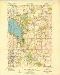
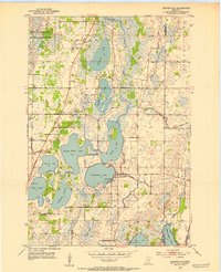
 1949 Lake Elmo1958 Print · USGSWashington County at the end of the 1940s is a landscape of rural schoolhouses and pristine glacial lakes. Researchers can locate numerous local landmarks like Union Cem, St John Sch, and the Chicago and North Western rail line.
 - 1949 Map of Hudson, 1958 Print
 1949 Hudson1958 Print · USGSThe St. Croix River valley at mid-century was a landscape of rail-connected river towns and small school districts. Genealogists can trace family roots through numerous local sites like Swede Hill Sch, St Peters Sch, and Lakeview Cem.2 unique versions available
 - 1950 Map of Lake Elmo
 1950 Lake Elmo1950 Print · USGSThe townships of Oakdale and Woodbury are captured in the mid-fifties, showing a landscape of small lakes and rural schoolhouses. Genealogists can trace family roots at Union Cem or locate historic school sites like Gillie Sch and Salem Sch.2 unique versions available
 - 1950 Map of Hudson
 1950 Hudson1950 Print · USGSThe St. Croix River valley at mid-century shows a network of thriving riverfront towns and rural school districts along the Minnesota-Wisconsin border. Researchers can trace the footprints of old schools like Ellmann Sch and Rentz Sch or locate the Toll Bridge connecting these two states.2 unique versions available
 - 1950 Map of St Paul Park, 1962 Print
 1950 St Paul Park1962 Print · USGSThe Mississippi River valley south of St. Paul is captured here at mid-century, showing the rail-dependent corridor between Newport and Nininger. Researchers can trace the legacy of local families through the Cottage Grove Cem and Sunny Hill Sch.
 - 1951 Map of St Paul Park
 1951 St Paul Park1951 Print · USGSSoutheast of the Twin Cities in the early 1950s, the river and rail lines dictated the growth of towns along the Mississippi. Researchers can trace family sites at Grey Cloud Cem, follow the rail junction at Langdon, or locate the historic riverfront settlement of Nininger.2 unique versions available
 - 1951 Map of Prescott
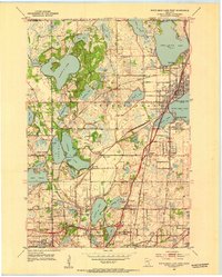
 1951 Prescott1951 Print · USGSThe river confluence at the Minnesota-Wisconsin border in the early fifties shows a landscape of busy waterways and rural school districts. Genealogists can locate family landmarks like the Johnson Cem and Barkley Sch near the Kinnickinnic River bluffs.4 unique versions available
 - 1951 Map of White Bear Lake East, 1952 Print
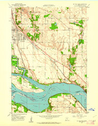
 1951 White Bear Lake East1952 Print · USGSThe lakeside communities of Washington County are shown at a point of significant growth in the early fifties. Genealogists and local historians can trace the early footprints of Mahtomedi, locate rural landmarks like Castle Sch, or identify the original site of the White Bear Airport.3 unique versions available
 - 1951 Map of Stillwater, 1952 Print
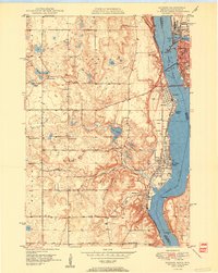
 1951 Stillwater1952 Print · USGSStillwater and the St. Croix River valley are captured in the early fifties, showcasing the area's transition from an industrial river hub to a modern regional center. Genealogists and historians can trace family roots through sites like the Minnesota State Prison, St Johns Ch, and the Boutwell Cem.4 unique versions available
 - 1951 Map of Inver Grove, 1953 Print
 1951 Inver Grove1953 Print · USGSThe Mississippi River valley south of St. Paul is documented here just as the post-war era began reshaping the Dakota County countryside. Researchers can trace the legacy of local education and faith at Rosemount Sch, St Patrick Cem, and the historic Pine Bend settlement.3 unique versions available
 - 1951 Map of St. Paul East, 1953 Print
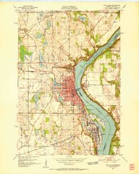
 1951 St. Paul East1953 Print · USGSSaint Paul during the early fifties reveals a thriving river-and-rail hub anchored by the State Capitol and a dense network of neighborhoods. Researchers can trace the mid-century city layout, from institutional landmarks like Gillette State Hospital to the industrial Stock Yards and Holman Airport.2 unique versions available
 - 1951 Map of St. Paul, 1959 Print
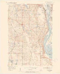
 1951 St. Paul1959 Print · USGSThe Twin Cities region during the post-war boom shows the rapid growth of St Paul and Minneapolis toward their southern suburbs. Genealogists and historians can trace numerous rural landmarks like School No 73, Roselawn Cemetery, and the St Johns Cem before suburban sprawl fully arrived.2 unique versions available
 - 1952 Map of Centerville, 1954 Print
 1952 Centerville1954 Print · USGSCenterville and the surrounding lake country of Anoka County are shown here in the early fifties, before suburban expansion reached these wetlands. Researchers can trace early rural life through landmarks like Rice Lake Ch, the Twitchel Cem, and a lakeside Seaplane Base.
 - 1952 Map of White Bear Lake West, 1954 Print
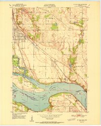
 1952 White Bear Lake West1954 Print · USGSRamsey County in the early fifties shows a landscape of expansive lakefronts and emerging suburbs before the peak of mid-century sprawl. Genealogists can trace early landmarks like Little Canada and Bethany Cem, or follow old rail lines through Cardigan Junction.3 unique versions available
 - 1953 Map of Saint Paul, 1964 Print
 1953 Saint Paul1964 Print · USGSThe Twin Cities and the Mississippi River valley are captured here at a mid-century turning point. Trace the early growth of Minneapolis and Saint Paul alongside landmarks like Lake Minnetonka and the St Croix River.4 unique versions available
Showing maps 1-25 of 139
Top cities of Washington County
- Woodbury historical maps
- Cottage Grove historical maps
- Stillwater historical maps
- Hugo historical maps
- Mahtomedi historical maps
- Lake Elmo historical maps
See more
Frequently asked questions
- What are the different types of historical maps available for Washington County?
- What is the oldest map of Washington County?
- Where can I purchase historical maps of Washington County for my home or office?
- Where can I download high-res historical maps of Washington County?
- Are there historical topographic maps available for Washington County?
- Is there historical aerial imagery available for Washington County?
- Where are historical maps of Washington County sourced from?