1950s Maps of Winona County, Minnesota
Explore 12 historic maps of Winona County from the 1950s. These maps offer a rare glimpse into what life looked like during the 1950s — showing old roads, neighborhoods, homes, and landmarks that have changed or disappeared over time.
Whether you're researching your family's past, planning a metal detecting trip, or studying how Winona County's landscape evolved across the 1950s, these high-resolution maps are a powerful tool for exploring the history of this region.
- Focus on a specific era: All maps on this page are from the 1950s, giving you a focused view of this time period.
- See what’s changed: Compare century-old streets, trails, and buildings to today's modern landscape using overlays and satellite layers.
- Research with precision: Use these maps for genealogy, historical research, land use analysis, or educational projects.
- View, download, or print: Maps are fully viewable online in high resolution, and can be downloaded or printed for your own records.
Start exploring Winona County's history through authentic maps from the 1950s. This is your window into the past.
Winona County, MN maps
(12)- 1953 Map of Saint Paul, 1964 Print
 1953 Saint Paul1964 Print · USGSThe Twin Cities and the Mississippi River valley are captured here at a mid-century turning point. Trace the early growth of Minneapolis and Saint Paul alongside landmarks like Lake Minnetonka and the St Croix River.4 unique versions available
 - 1953 Map of Eau Claire, 1965 Print
 1953 Eau Claire1965 Print · USGSWest-central Wisconsin in the mid-fifties shows a landscape of river-valley industry and vast wildlife refuges during the transition from rails to modern highways. Genealogists and historians can trace the rail corridors of the Chicago and North Western or locate family-named landmarks like Decorah Mound and Chippewa Island.4 unique versions available
 - 1954 Map of Chatfield, 1956 Print
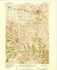 1954 Chatfield1956 Print · USGSSoutheastern Minnesota's river valleys and rail towns are captured here in the mid-1950s, showing the region's transition from a rural schoolhouse network to modern townships. Genealogists can locate family-named landmarks like Loughrey Sch or Casper Sch and early church sites such as Root Prairie Ch.2 unique versions available
 - 1954 Map of Lewiston, 1956 Print
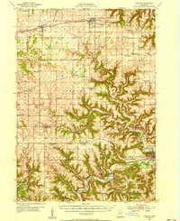 1954 Lewiston1956 Print · USGSSoutheast Minnesota’s transition from prairie to deep river coulees is captured here in the mid-1950s. Genealogists can locate dozens of rural landmarks, from Lodahl School and Jenkins School to the Brethren Church and the Fish Hatchery near Peterson.2 unique versions available
 - 1954 Map of Mason City, 1967 Print
 1954 Mason City1967 Print · USGSSouthern Minnesota and northern Iowa are shown here at the height of the mid-century rail era, centered on the regional hubs of Mason City and Rochester. Researchers can trace the vanished paths of the Chicago Great Western and find local landmarks like Pilot Knob and Bear Lake.2 unique versions available
 - 1956 Map of La Crescent, 1958 Print
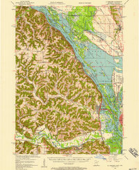 1956 La Crescent1958 Print · USGSThe Mississippi River borderlands thrive in the mid-fifties, showing the transition from the high ridges of Houston and Winona counties to the Wisconsin prairie. Genealogists can trace family names across South Ridge Ch, Loretta Sch, and cemeteries like Crucifixion Cem.2 unique versions available
 - 1957 Map of Mason City
 1957 Mason City1957 Print · USGSThe Minnesota-Iowa border region comes alive in this mid-century survey, from the industrial plants of Mason City to the medical hub of Rochester. Researchers can trace the rail-and-river economy through the Chicago Great Western Railway and the Shell Rock River.
 - 1958 Map of Mason City
 1958 Mason City1958 Print · USGSSouthern Minnesota and northern Iowa are shown during the mid-fifties when railroads still anchored the regional economy. Genealogists and historians can trace the intricate rail networks of the Illinois Central and find local landmarks in Mason City, Albert Lea, and Austin.
 - 1958 Map of Eau Claire
 1958 Eau Claire1958 Print · USGSWestern Wisconsin in the late fifties shows a landscape of growing regional hubs and massive wildlife refuges. Trace the rail lines of the Chicago and North Western between Eau Claire and Marshfield, or explore the terrain around Iron Mound and Lake Wissota.
 - 1958 Map of Houston, 1959 Print
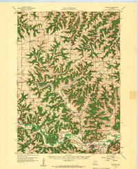 1958 Houston1959 Print · USGSSoutheast Minnesota in the late fifties shows a landscape of deep valleys and high ridges centered on Houston. Genealogists can trace rural life through numerous landmarks like Vinegar Hill Sch, St Patricks Cem Ch, and the Milwaukee St Paul and Pacific rail line.2 unique versions available
 - 1958 Map of La Crosse, 1979 Print
 1958 La Crosse1979 Print · USGSThe Driftless Area of Wisconsin and Iowa is captured here during the late seventies, showing the intricate river valleys and ridge-top settlements. Genealogists and historians can trace the rail corridors of the Soo Line or locate landmarks like Grandad Bluff and Effigy Mounds National Monument.2 unique versions available
 - 1959 Map of Saint Paul
 1959 Saint Paul1959 Print · USGSThe Twin Cities and southeastern Minnesota appear here in the late fifties, showing the peak of the rail era and post-war suburban growth. Genealogists can trace family footprints near Lake Minnetonka, the Univ Of Minn Rosemount Research Center, or the growing neighborhoods of Richfield.2 unique versions available
End of results
Showing maps 1-12 of 12
Top cities of Winona County
- Winona historical maps
- Goodview historical maps
- Lewiston historical maps
- Homer historical maps
- Wilson historical maps
- Stockton historical maps
See more
Frequently asked questions
- What are the different types of historical maps available for Winona County?
- What is the oldest map of Winona County?
- Where can I purchase historical maps of Winona County for my home or office?
- Where can I download high-res historical maps of Winona County?
- Are there historical topographic maps available for Winona County?
- Is there historical aerial imagery available for Winona County?
- Where are historical maps of Winona County sourced from?