1970s Maps of Winona County, Minnesota
Explore 21 historic maps of Winona County from the 1970s. These maps offer a rare glimpse into what life looked like during the 1970s — showing old roads, neighborhoods, homes, and landmarks that have changed or disappeared over time.
Whether you're researching your family's past, planning a metal detecting trip, or studying how Winona County's landscape evolved across the 1970s, these high-resolution maps are a powerful tool for exploring the history of this region.
- Focus on a specific era: All maps on this page are from the 1970s, giving you a focused view of this time period.
- See what’s changed: Compare century-old streets, trails, and buildings to today's modern landscape using overlays and satellite layers.
- Research with precision: Use these maps for genealogy, historical research, land use analysis, or educational projects.
- View, download, or print: Maps are fully viewable online in high resolution, and can be downloaded or printed for your own records.
Start exploring Winona County's history through authentic maps from the 1970s. This is your window into the past.
Winona County, MN maps
(21)- 1972 Map of Winona West, 1975 Print
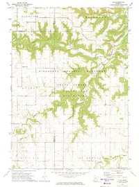
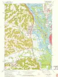
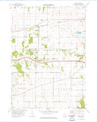
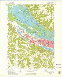 1972 Winona West1975 Print · USGSThe riverfront city of Winona is shown in the early seventies as a thriving center for education and rail transit. Researchers can trace the grounds of Winona State College, the corridors of the Chicago and North Western, and landmarks like Sugarloaf.3 unique versions available
 - 1972 Map of Winona East, 1975 Print
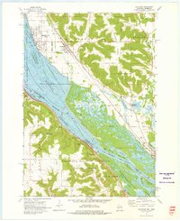
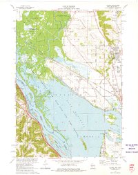
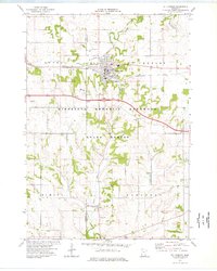
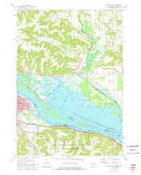 1972 Winona East1975 Print · USGSThe riverfront and steep bluffs of the upper Mississippi are captured here in the early seventies. Genealogists and historians can locate St Marys Cem, trace the rail lines through Bluff Siding, and see the footprint of Winona and its schools.3 unique versions available
 - 1972 Map of Beaver, 1975 Print
 1972 Beaver1975 Print · USGSSoutheast Minnesota's bluff country is captured here in the early seventies, showing the junction of the Whitewater River and Beaver Creek. Genealogists can locate several rural burial sites, including Beaver Cem and Hoosier Ridge Cem, along with the Hoosier Ridge Ch.2 unique versions available
 - 1972 Map of Fountain City, 1975 Print
 1972 Fountain City1975 Print · USGSFountain City and the Mississippi River bluffs are captured in the early seventies, showing a landscape of steep ridges and deep valleys. Researchers can locate family landmarks like St Marys Cem, trace the Burlington Northern line, or explore Merrick State Park.
 - 1972 Map of Elba, 1975 Print
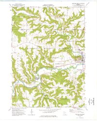
 1972 Elba1975 Print · USGSSoutheast Minnesota's bluff country is captured here in the 1970s, where the Whitewater River forks converge near the town of Elba. Researchers can locate rural landmarks such as St Aloysius Cem, the Lookout Tower, and the remote crossroads of Kingsley Corner.2 unique versions available
 - 1972 Map of Cochrane, 1976 Print
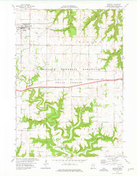
 1972 Cochrane1976 Print · USGSThe upper Mississippi riverfront and its surrounding bluffs are captured here in the early seventies, showing a landscape defined by navigation and nature. Genealogists and historians can trace the streets of Cochrane, locate the Mount Vernon Cem, and see the rail lines of the Burlington Northern.2 unique versions available
 - 1972 Map of Rollingstone, 1976 Print
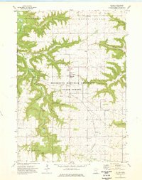
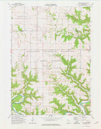
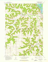 1972 Rollingstone1976 Print · USGSThe steep valleys of Winona County are seen here in the early seventies, dominated by the wooded bluffs of the Minnesota Memorial Hardwood State Forest. Trace the rail lines of the Chicago and North Western or locate the Mecklenburg Cem and Immanuel Sch.2 unique versions available
 - 1972 Map of Weaver, 1976 Print
 1972 Weaver1976 Print · USGSThe river bluffs and backwaters of Winona County are captured in the early seventies, showing a landscape shaped by timber and the Mississippi. Researchers can trace the tracks of the Chicago Milwaukee St Paul and Pacific and locate local landmarks like St Marys Cem Evergreen Sem or Mount Vernon.2 unique versions available
 - 1972 Map of Altura, 1976 Print
 1972 Altura1976 Print · USGSThe Winona County uplands near the Whitewater River are shown here in the early 1970s as a landscape of deep valleys and forest conservation. Researchers can trace the Old Railroad Grade and find rural landmarks like Hebron Ch, the State Fish Hatchery, and Bethany.2 unique versions available
 - 1973 Map of Pickwick, 1975 Print
 1973 Pickwick1975 Print · USGSThe Mississippi River bluffs and valleys of Winona County are captured here in the mid-1970s. Genealogists and local historians can trace family locations from Pickwick and Dakota to rural sites like Wilson Cemetery and New Hartford.2 unique versions available
 - 1973 Map of Mound Prairie, 1975 Print
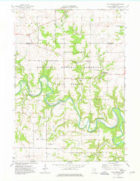
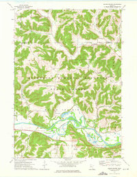 1973 Mound Prairie1975 Print · USGSHouston County's winding river valleys and high ridges are shown here in the mid-1970s, as the railroad still followed the water's edge. Researchers can locate family landmarks such as Loretta Cem, the South Ridge Ch, and the small settlement of Mound Prairie.
 - 1973 Map of Trempealeau, 1975 Print
 1973 Trempealeau1975 Print · USGSThe Mississippi River bluffs and riverfront at Trempealeau are shown in the early seventies as a major rail hub. Trace the junction of three railroads near Trempealeau and explore the rugged river landscape of Perrot State Park and Eagle Bluff.
 - 1973 Map of La Crescent, 1976 Print
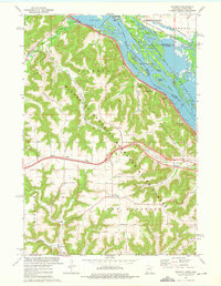
 1973 La Crescent1976 Print · USGSThe Mississippi River valley in the early seventies shows a complex landscape of island refuges and bluff-side settlements. Genealogists and historians can trace the tracks of the Chicago Milwaukee St Paul and Pacific and locate historic sites like Crucifixion Cem or Hokah.
 - 1973 Map of Holmen, 1976 Print
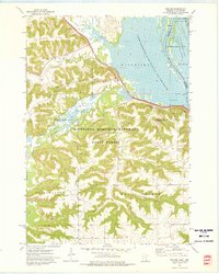
 1973 Holmen1976 Print · USGSThe Upper Mississippi riverfront and its wide prairie terraces are documented here in the early 1970s. Researchers can locate family landmarks like Oak Grove Sch and Green Mound Cem, or trace the rail lines through Midway and Dresbach.
 - 1974 Map of Rushford West, 1976 Print
 1974 Rushford West1976 Print · USGSFillmore County river towns and blufflands are captured here in the mid-seventies as the rail-and-river economy shaped the valley. Researchers can trace local lineages through West Grace Cem and Hungerholdt Cem, or locate landmarks like the Fish Hatchery.
 - 1974 Map of Pilot Mound, 1976 Print
 1974 Pilot Mound1976 Print · USGSFillmore County's winding river valleys and bluff-top farms are frozen in time during the mid-seventies. Researchers can trace historic landmarks like Root Prairie Ch and the curious settlement of Bucksnort or locate family plots in the Pilot Mound Cem.
 - 1974 Map of Utica, 1976 Print
 1974 Utica1976 Print · USGSWinona County's agricultural and forest lands are documented here in the mid-1970s, as rail and road networks connected rural communities. Researchers can trace local heritage through sites like the Scottish Ch, St John Cem, and the path of the Chicago and North Western.
 - 1974 Map of St Charles, 1976 Print
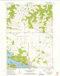
 1974 St Charles1976 Print · USGSThe city of St Charles and the surrounding townships are captured in the mid-seventies, showing a landscape defined by the Chicago and North Western railroad. Researchers can locate several historic burial grounds, such as Hillside Cem and Sinclair Cem, or trace the winding banks of the South Fork Whitewater River.
 - 1974 Map of Lewiston, 1976 Print
 1974 Lewiston1976 Print · USGSSoutheastern Minnesota's ridge and valley landscape is captured in the mid-seventies, centered on the growing community of Lewiston. Researchers can trace family history through sites like Warren Cem, SS Peter and Paul Ch, and the small settlement of Wyattville.
 - 1974 Map of Arendahl, 1976 Print
 1974 Arendahl1976 Print · USGSFillmore County was characterized by its river bluffs and upland prairies in the mid-1970s. You can trace the path of the C M St P & P railroad along the Root River or locate the historic North Prairie Ch and Arendahl Cem.
 - 1976 Map of La Crosse
 1976 La Crosse1976 Print · USGSThe Driftless Area and Mississippi River valley are captured here in the mid-seventies, showing a landscape of deep coulees and river commerce. Genealogists can trace family footprints from La Crosse to smaller hamlets like Newburg Corners and Witoka.
End of results
Showing maps 1-21 of 21
Top cities of Winona County
- Winona historical maps
- Goodview historical maps
- Lewiston historical maps
- Homer historical maps
- Wilson historical maps
- Stockton historical maps
See more
Frequently asked questions
- What are the different types of historical maps available for Winona County?
- What is the oldest map of Winona County?
- Where can I purchase historical maps of Winona County for my home or office?
- Where can I download high-res historical maps of Winona County?
- Are there historical topographic maps available for Winona County?
- Is there historical aerial imagery available for Winona County?
- Where are historical maps of Winona County sourced from?