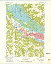
1972 Map of Winona West
USGS Topo · Published 1975About this map
The riverfront city of Winona dominates this early 1970s landscape, positioned between the high bluffs and the intricate islands of the Mississippi River. This era shows a community deeply rooted in education and faith, featuring Winona State College, College of St Teresa, and St Marys College alongside numerous parochial institutions like St Marys Sch. The river itself is a complex network of channels such as Indian Channel and Straight Slough, bordered by the Upper Mississippi River Wild Life and Fish Refuge.
Find a feature on this map
52 named features on this map. Tap any name to fly to it.
Don’t see what you’re looking for? This feature index may not catch every label — zoom into the map to look around manually.
Map Details
Editions of this 1972 Winona West Map
3 editions found
Other maps of this area

1929 · Fountain City
USGS Topo · 1:62,500

1932 · Cochrane
USGS Topo · 1:62,500

1934 · Winona
USGS Topo · 1:62,500

1934 · Cochrane
USGS Topo · 1:62,500

1937 · Winona
USGS Topo · 1:62,500

1937 · Cochrane
USGS Topo · 1:62,500

1953 · Eau Claire
USGS Topo · 1:250,000

1954 · Lewiston
USGS Topo · 1:62,500

1958 · Eau Claire
USGS Topo · 1:250,000

1958 · Houston
USGS Topo · 1:62,500