1932 Map of Cochrane
USGS Topo · Published 1932About this map
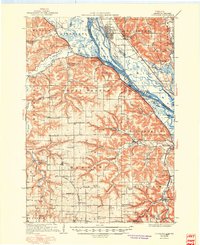
The Mississippi River dominates this landscape, weaving a complex network of channels and backwaters such as Middle Slough and Sand Run along the western edge of Belvidere and Milton. The 1932 map reveals a river valley in transition, where large landmasses like Somerfield Island, Keller Island, and Muench Island fragment the water's path. Infrastructure clings to the base of the prominent Belvidere Ridge, with the Chicago Burlington and Quincy railroad and State Trunk Highway No 35 providing the primary transit corridor through Buffalo City and Cochrane.
Find a feature on this map
22 named features on this map. Tap any name to fly to it.
Don’t see what you’re looking for? This feature index may not catch every label — zoom into the map to look around manually.
Map Details
Editions of this 1932 Cochrane Map
This is the sole edition of this map. No revisions or reprints were ever made.
Historical Maps of Goodview Through Time
5 maps found