
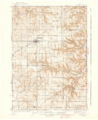
1938 Map of Plainview
USGS Topo · Published 1938About this map
Plainview serves as the central hub of this 1930s landscape, situated atop a high plateau where the Chicago and North Western railroad cuts across the agricultural plains of Wabasha County. To the east and south, the terrain breaks sharply into the deep, winding valleys of the Whitewater River and its multiple forks. This area is defined by a dense network of country school districts, including Hoosier Ridge Sch, Pleasant Valley Sch, and Melindy Sch, which served the rural farming families before mid-century consolidation. The map reveals the early footprint of Whitewater State Park and the Wabasha County Fair Grounds, alongside small crossroads such as Kingsley Corner and the riverside settlement of Elba. Prominent physical landmarks like Rattlesnake Ridge and Fisher Hill overlook the deeply incised Sleepy Valley Creek and Whiskey Creek.
Find a feature on this map
80 named features on this map. Tap any name to fly to it.
Don’t see what you’re looking for? This feature index may not catch every label — zoom into the map to look around manually.
Map Details
Editions of this 1938 Plainview Map
2 editions found
Other maps of this area

1932 · Cochrane
USGS Topo · 1:62,500

1932 · Wabasha
USGS Topo · 1:62,500

1932 · Alma
USGS Topo · 1:62,500

1934 · Plainview
USGS Topo · 1:62,500

1934 · Cochrane
USGS Topo · 1:62,500

1935 · Rochester
USGS Topo · 1:48,000

1937 · Cochrane
USGS Topo · 1:62,500

1939 · Rochester
USGS Topo · 1:62,500
1950 · Alma
USGS Topo · 1:62,500

1951 · Wabasha
USGS Topo · 1:62,500