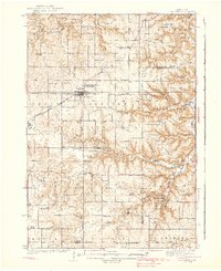
1938 Map of Plainview
USGS Topo · Published 1938About this map
Plainview serves as the primary hub of this landscape, situated at the junction of the Chicago and North Western railroad and local transport routes. The 1934 survey highlights a highly developed network of rural education, with dozens of family-named and numbered schoolhouses such as Harlan Sch, Melindy Sch, and Six Oaks Sch dotting the township grids. These structures, along with the Wabasha County Fair Grounds, reflect the social and civic organization of the pre-war period.
Find a feature on this map
81 named features on this map. Tap any name to fly to it.
Don’t see what you’re looking for? This feature index may not catch every label — zoom into the map to look around manually.
Map Details
Editions of this 1938 Plainview Map
2 editions found
Other maps of this area

1932 · Cochrane
USGS Topo · 1:62,500

1932 · Wabasha
USGS Topo · 1:62,500

1932 · Alma
USGS Topo · 1:62,500

1934 · Plainview
USGS Topo · 1:62,500

1934 · Cochrane
USGS Topo · 1:62,500

1935 · Rochester
USGS Topo · 1:48,000

1937 · Cochrane
USGS Topo · 1:62,500

1938 · Plainview
USGS Topo · 1:62,500

1939 · Rochester
USGS Topo · 1:62,500

1950 · Alma
USGS Topo · 1:62,500