
1934 Map of Plainview
USGS Topo · Published 1960About this map
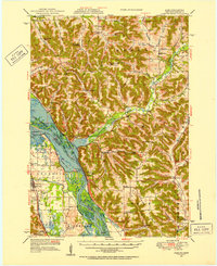
The town of Plainview serves as a central hub for the surrounding agricultural landscape in this 1934 survey, where the Chicago and North Western railway cuts a diagonal line toward Elgin. The terrain shifts dramatically from the flat prairie in the west to the deeply carved valleys of the Whitewater River system in the east. This eastern portion is dominated by topographic landmarks like Rattlesnake Ridge and Hoosier Ridge, with the Whitewater State Park preserving the river's sharp bends and forested bluffs.
Find a feature on this map
77 named features on this map. Tap any name to fly to it.
Don’t see what you’re looking for? This feature index may not catch every label — zoom into the map to look around manually.
Map Details
Editions of this 1934 Plainview Map
This is the sole edition of this map. No revisions or reprints were ever made.
Other maps of this area

1932 · Cochrane
USGS Topo · 1:62,500

1932 · Wabasha
USGS Topo · 1:62,500

1932 · Alma
USGS Topo · 1:62,500

1934 · Cochrane
USGS Topo · 1:62,500

1935 · Rochester
USGS Topo · 1:48,000

1937 · Cochrane
USGS Topo · 1:62,500

1938 · Plainview
USGS Topo · 1:62,500

1939 · Rochester
USGS Topo · 1:62,500
1950 · Alma
USGS Topo · 1:62,500

1951 · Wabasha
USGS Topo · 1:62,500