
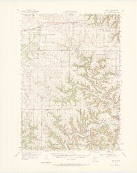
1954 Map of Lewiston
USGS Topo · Published 1956About this map
Lewiston and Utica anchor the northern prairie landscape of this mid-1950s survey, where the Chicago And North Western railroad cuts a straight line through the townships of Utica and Warren. The geography shifts dramatically toward the south, where the high plains break into the deeply incised valleys of the Root River and Rush Creek. This transition from flat farmland to the driftless-style coulee country is marked by a dense network of country schoolhouses, such as Enterprise Sch and Wyattville Sch, which served the scattered dairy and grain farms of the era.
Find a feature on this map
74 named features on this map. Tap any name to fly to it.
Don’t see what you’re looking for? This feature index may not catch every label — zoom into the map to look around manually.
Map Details
Editions of this 1954 Lewiston Map
2 editions found
Other maps of this area

1929 · Fountain City
USGS Topo · 1:62,500

1932 · Cochrane
USGS Topo · 1:62,500

1934 · Winona
USGS Topo · 1:62,500

1934 · Plainview
USGS Topo · 1:62,500

1934 · Cochrane
USGS Topo · 1:62,500

1937 · Winona
USGS Topo · 1:62,500

1937 · Cochrane
USGS Topo · 1:62,500

1938 · Plainview
USGS Topo · 1:62,500

1953 · Saint Paul
USGS Topo · 1:250,000

1953 · Eau Claire
USGS Topo · 1:250,000