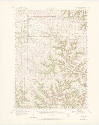
1954 Map of Lewiston
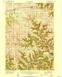
USGS Topo · Published 1974About this map
Root River and its winding tributaries like Rush Creek carve deep valleys through the southeastern Minnesota landscape, creating a distinct topographical contrast between the high agricultural plateaus and the sheltered lowlands. In the mid-1950s, this region was defined by a dense network of one-room schoolhouses such as Vowel Sch, Wraalstad Sch, and Ask Sch, alongside country churches including Brethren Ch and SS Peter and Paul Ch. These institutions served a farming population clustered around rail hubs like Utica, Lewiston, and Rushford. The transportation corridor is anchored by the Chicago and North Western in the north and the Milwaukee ST Paul And Pacific along the river in the south. The presence of specialized infrastructure, such as the Fish Hatchery near Peterson, suggests a landscape managed for both utility and conservation alongside traditional limestone Quarries.
Find a feature on this map
74 named features on this map. Tap any name to fly to it.
Don’t see what you’re looking for? This feature index may not catch every label — zoom into the map to look around manually.
Map Details
Editions of this 1954 Lewiston Map
2 editions found
Other maps of this area

1929 · Fountain City
USGS Topo · 1:62,500

1932 · Cochrane
USGS Topo · 1:62,500

1934 · Winona
USGS Topo · 1:62,500

1934 · Plainview
USGS Topo · 1:62,500

1934 · Cochrane
USGS Topo · 1:62,500

1937 · Winona
USGS Topo · 1:62,500

1937 · Cochrane
USGS Topo · 1:62,500

1938 · Plainview
USGS Topo · 1:62,500

1953 · Saint Paul
USGS Topo · 1:250,000

1953 · Eau Claire
USGS Topo · 1:250,000