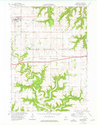
1974 Map of Lewiston
USGS Topo · Published 1976About this map
The city of Lewiston serves as the focal point of this mid-1970s survey, situated where the Chicago and North Western corridor cuts through the high plains of Winona County. The landscape transitions quickly from agricultural tablelands into the deeply dissected valleys of the Minnesota Memorial Hardwood State Forest. Watercourses such as Garvin Brook, Rush Creek, and Stockton Valley Creek have carved intricate drainage patterns through the terrain, defining the local topography and land use.
Find a feature on this map
21 named features on this map. Tap any name to fly to it.
Don’t see what you’re looking for? This feature index may not catch every label — zoom into the map to look around manually.
Map Details
Editions of this 1974 Lewiston Map
This is the sole edition of this map. No revisions or reprints were ever made.
Other maps of this area

1929 · Fountain City
USGS Topo · 1:62,500

1932 · Cochrane
USGS Topo · 1:62,500

1934 · Winona
USGS Topo · 1:62,500

1934 · Cochrane
USGS Topo · 1:62,500

1937 · Winona
USGS Topo · 1:62,500

1937 · Cochrane
USGS Topo · 1:62,500

1953 · Eau Claire
USGS Topo · 1:250,000

1954 · Lewiston
USGS Topo · 1:62,500

1958 · Eau Claire
USGS Topo · 1:250,000

1958 · Houston
USGS Topo · 1:62,500