1980s Maps of Olio, Mississippi
Explore 2 historic maps of Olio from the 1980s. These maps offer a rare glimpse into what life looked like during the 1980s — showing old roads, neighborhoods, homes, and landmarks that have changed or disappeared over time.
Whether you're researching your family's past, planning a metal detecting trip, or studying how Olio's landscape evolved across the 1980s, these high-resolution maps are a powerful tool for exploring the history of this region.
- Focus on a specific era: All maps on this page are from the 1980s, giving you a focused view of this time period.
- See what’s changed: Compare century-old streets, trails, and buildings to today's modern landscape using overlays and satellite layers.
- Research with precision: Use these maps for genealogy, historical research, land use analysis, or educational projects.
- View, download, or print: Maps are fully viewable online in high resolution, and can be downloaded or printed for your own records.
Start exploring Olio's history through authentic maps from the 1980s. This is your window into the past.
Olio, MS maps
(2)- 1984 Map of McComb
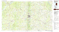 1984 McComb1984 Print · USGSSouth Mississippi in the mid-eighties was defined by the rail corridor connecting McComb and Magnolia to the surrounding timberlands. You can trace the rural network of Pike County through landmarks like Holmesville, Percy Quin State Park, and the winding Bogue Chitto.
 - 1988 Map of Berwick
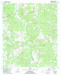 1988 Berwick1988 Print · USGSAmite County in the late eighties shows a landscape of small settlements and family-named landmarks connected by winding creek-side roads. Researchers can trace rural lineages through sites like Ariel, Olio, and the grounds of Ebenezer Ch and Garner Cem.
End of results
Showing maps 1-2 of 2
Top cities near Olio
- Clinton historical maps
- Centreville historical maps
- Gloster historical maps
- Wilson historical maps
- Liberty historical maps
- Norwood historical maps
Frequently asked questions
- What are the different types of historical maps available for Olio?
- What is the oldest map of Olio?
- Where can I purchase historical maps of Olio for my home or office?
- Where can I download high-res historical maps of Olio?
- Are there historical topographic maps available for Olio?
- Is there historical aerial imagery available for Olio?
- Where are historical maps of Olio sourced from?