1980s Maps of Dossville, Mississippi
Explore 2 historic maps of Dossville from the 1980s. These maps offer a rare glimpse into what life looked like during the 1980s — showing old roads, neighborhoods, homes, and landmarks that have changed or disappeared over time.
Whether you're researching your family's past, planning a metal detecting trip, or studying how Dossville's landscape evolved across the 1980s, these high-resolution maps are a powerful tool for exploring the history of this region.
- Focus on a specific era: All maps on this page are from the 1980s, giving you a focused view of this time period.
- See what’s changed: Compare century-old streets, trails, and buildings to today's modern landscape using overlays and satellite layers.
- Research with precision: Use these maps for genealogy, historical research, land use analysis, or educational projects.
- View, download, or print: Maps are fully viewable online in high resolution, and can be downloaded or printed for your own records.
Start exploring Dossville's history through authentic maps from the 1980s. This is your window into the past.
Dossville, MS maps
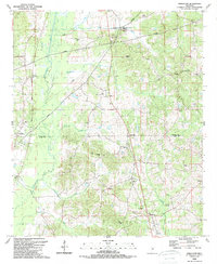
(2)- 1984 Map of Carthage
 1984 Carthage1984 Print · USGSLeake and Neshoba counties in the mid-1980s showcase a transition from the Government Hills to the dense Bienville National Forest. Genealogists and researchers can trace the historic Natchez Trace Parkway and local settlements like Plattsburg and Williamsville.
 - 1989 Map of Singleton
 1989 Singleton1989 Print · USGSThe Attala and Leake County line comes alive in the late 1980s, showcasing a rural landscape defined by the Natchez Trace Parkway and the Yockanookany River. Researchers can trace old family burial sites at Delydia Hill Cem and Turnage Cem.
End of results
Showing maps 1-2 of 2
Top cities near Dossville
Frequently asked questions
- What are the different types of historical maps available for Dossville?
- What is the oldest map of Dossville?
- Where can I purchase historical maps of Dossville for my home or office?
- Where can I download high-res historical maps of Dossville?
- Are there historical topographic maps available for Dossville?
- Is there historical aerial imagery available for Dossville?
- Where are historical maps of Dossville sourced from?