Old Maps of Benton County, Mississippi
Explore 95 old maps of Benton County, spanning from 1944 to today. These high-resolution historic maps reveal how streets, neighborhoods, landmarks, and natural features evolved over time — perfect for genealogy, metal detecting, research, and local history exploration.
What you can do with these maps:
- See how Benton County changed over time: Compare historical maps to modern-day views to trace roads, homesites, rail lines & more.
- View detailed metadata: Each map includes creators, publishers, year, scale, and archive source.
- Overlay maps with satellite & LiDAR: Visualize the past alongside modern tools to explore terrain & human change.
- Trusted historical sources: Maps sourced from the USGS, Library of Congress, and other archives.
- Access maps your way: View online, download high-res files, or order prints for personal or research use.
Start exploring old maps of Benton County to uncover forgotten places, hidden landmarks, and the deep history beneath your feet.
Benton County, MS maps
(95)- 1944 Map of Potts Camp, 1973 Print
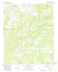
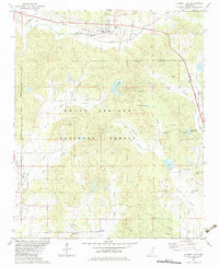
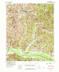 1944 Potts Camp1973 Print · USGSMarshall County's rural landscape is captured here during the mid-1940s, highlighting the area's transition between the national forest and the Tallahatchie valley. Researchers can trace family sites at St Pauls Ch & Cem, the community at Potts Camp, and early engineering like the Tallahatchie Canal.
 - 1945 Map of Potts Camp, 1964 Print
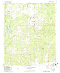
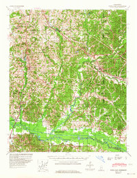 1945 Potts Camp1964 Print · USGSNorth Mississippi's rural timber and farm country comes into focus in the mid-1940s, just as the local landscape was being reshaped by large-scale flood control projects. Genealogists can locate family landmarks such as Bethany Ch & Cem, the Winborn Lookout Tower, and small settlements like Cornersville and Malone.
 - 1950 Map of Ashland, 1952 Print
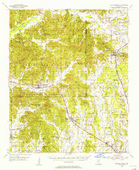
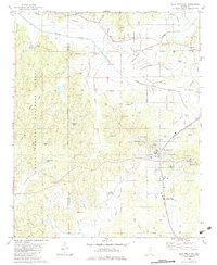
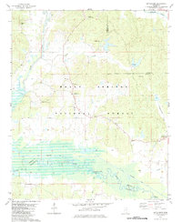
 1950 Ashland1952 Print · USGSBenton County at the mid-century is captured here as a landscape of small timber towns and forest clearings before modern development. You can trace early school sites like Holloway Sch and family-centered landmarks such as Whitten Town and Hunters Chapel.3 unique versions available
 - 1953 Map of Holly Springs
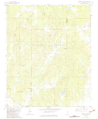
 1953 Holly Springs1953 Print · USGSNorth-central Mississippi and the Tennessee borderlands are captured here in the early 1950s, centered on the railroad crossing at Holly Springs. Genealogists can trace family locations through numerous rural sites like Hudsonville Ch & Cem and Slayden Sch.
 - 1955 Map of Blue Mountain, 1956 Print
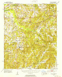
 1955 Blue Mountain1956 Print · USGSTippah and Union counties are shown in the mid-fifties during a period of steady growth along the regional rail lines. Researchers can trace family sites among dozens of landmarks like St Matthew Ch, Pumpkin Center, and the Myrtle Lookout Tower.3 unique versions available
 - 1956 Map of Tupelo, 1967 Print
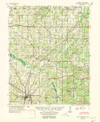
 1956 Tupelo1967 Print · USGSNortheast Mississippi and parts of Tennessee and Alabama are shown here during the mid-fifties, a time of major reservoir construction and forestry management. Researchers can trace the St Louis-San Francisco RR through Tupelo or locate historic sites like Tishomingo State Park and the University.2 unique versions available
 - 1958 Map of Tupelo
 1958 Tupelo1958 Print · USGSNortheast Mississippi and neighboring Alabama and Tennessee appear here during the late fifties as a region defined by new reservoirs and historic rail lines. Genealogists can trace family locations near Sardis Lake, Woodall Mountain, and the St Louis-San Francisco Ry.
 - 1964 Map of Holly Springs SE, 1966 Print
 1964 Holly Springs SE1966 Print · USGSNorthern Mississippi in the mid-sixties reveals a landscape defined by the Holly Springs National Forest and the Illinois Central rail line. Researchers can trace rural landmarks from Hudsonville to Chestnut Grove Cem and Royston Chapel.2 unique versions available
 - 1965 Map of Lamar, 1966 Print
 1965 Lamar1966 Print · USGSBenton County, Mississippi, and Fayette County, Tennessee, meet in the mid-1960s along a landscape defined by the ILLINOIS CENTRAL railroad. Researchers can trace family roots through numerous local sites like Lamar Cem, Hickory Hill Cem, and Berry Chapel.2 unique versions available
 - 1969 Map of Holly Springs
 1969 Holly Springs1969 Print · USGSNorthern Mississippi and the Tennessee borderlands are detailed here in the late sixties, centered on the rail crossroads of Holly Springs. Genealogists and local historians can trace hundreds of rural landmarks, including Early Grove Cem, Roberts Chapel, and the Sand Flats Jr High Sch.
 - 1982 Map of Blue Mountain, 1983 Print
 1982 Blue Mountain1983 Print · USGSBlue Mountain and the Tippah County countryside are captured here in the late seventies, showing a landscape of small-town institutions and timbered forest. Genealogists can trace family landmarks like Rutherford Cem, Gravestown, and Beulah Hill Ch.
 - 1982 Map of Myrtle, 1983 Print
 1982 Myrtle1983 Print · USGSThe hills and river bottoms of Union County are captured here in the early eighties as rural life centered around the Illinois Central Gulf rail line. Genealogists and local historians can trace old community hubs like Old Myrtle, Cotton Plant, and Zion Hill Ch.
 - 1982 Map of Potts Camp, 1983 Print
 1982 Potts Camp1983 Print · USGSPotts Camp and the surrounding pine-oak woods of Marshall County are shown here in the early eighties as a landscape of timber and transit. Researchers can trace the Burlington Northern line through Potts Camp and Winborn or locate family sites like Butler Cem and Temperance Hill Ch.
 - 1982 Map of Chilli Creek, 1983 Print
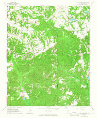
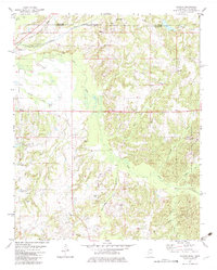
 1982 Chilli Creek1983 Print · USGSBenton County in the early eighties was a landscape of dense forestry and quiet rural settlements. Genealogists and local historians can trace family locations through numerous sites like Pisgah Cem, the settlement at Pine Grove, and Fox Hunters Lake.
 - 1982 Map of Camp Hill, 1983 Print
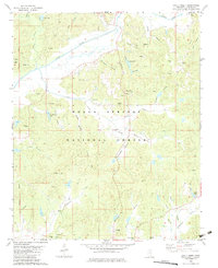
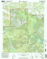
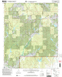
 1982 Camp Hill1983 Print · USGSThe rural borderlands of Mississippi and Tennessee are captured here in the early eighties, centered on the Holly Springs National Forest. Researchers can trace genealogical roots through numerous sites like Zion Chapel Cem, Wesley Cem, and the small settlement at New Canaan.
 - 1982 Map of Ashland, 1983 Print
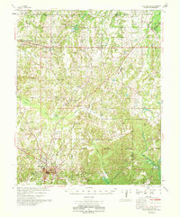
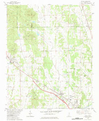
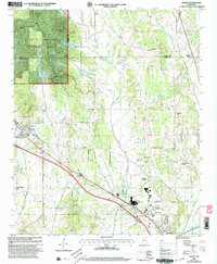
 1982 Ashland1983 Print · USGSBenton County is documented in the early eighties as the town of Ashland anchors a landscape of small schools and rural churches. Researchers can trace family sites at Bethlehem Cem, Gray Academy, and the Old Salem Sch.
 - 1982 Map of Bethlehem, 1983 Print
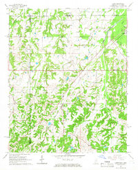
 1982 Bethlehem1983 Print · USGSNorthern Mississippi in the early eighties shows a landscape of timbered forest and river bottomlands. Trace family roots through rural landmarks like Bethlehem, the Macedonia Cem, and several country churches including Mt Olive Ch.
 - 1982 Map of Whitten Town, 1983 Print
 1982 Whitten Town1983 Print · USGSBenton and Tippah Counties appear here in the early eighties as a landscape of timber and quiet hill communities. Researchers can locate numerous ancestral sites like Whitten Town, Shelby Creek Cem, and country churches including Little Hope Ch.
 - 1982 Map of Hickory Flat, 1983 Print
 1982 Hickory Flat1983 Print · USGSBenton and Union counties in the early 1980s are defined here by rural rail towns and the deep woods of the Holly Springs National Forest. Researchers can locate legacy family sites and landmarks like Amaziah Ch, Old Myrtle, and the Myrtle Lookout Tower.
 - 1982 Map of Canaan, 1983 Print
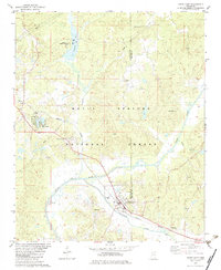
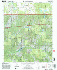
 1982 Canaan1983 Print · USGSBenton County, Mississippi, sits along the Tennessee state line in the early eighties, a landscape of timber and river bottoms. Family historians can trace small communities like Spring Hill and Canaan, alongside numerous burial sites including Valentine Cem and Fleet Cem.
 - 1984 Map of Tupelo
 1984 Tupelo1984 Print · USGSNorth Mississippi in the 1980s is defined by its massive river basin reservoirs and the growing regional hubs of Tupelo and Oxford. Researchers can trace the legacy of the Pontotoc Ridge, find the University of Mississippi, and map early Interstate corridors near Sardis Lake.3 unique versions available
 - 2000 Map of Myrtle, 2003 Print
 2000 Myrtle2003 Print · USGSNorthern Mississippi's rural landscape is captured here at the millennium, centered on Myrtle and the Heipsy Hills. Genealogists can trace family names at Graves Myrtle Cem, McAllister Cem, and the Bois D'Arc Ch.
 - 2000 Map of Camp Hill, 2003 Print
 2000 Camp Hill2003 Print · USGSThe northern border of Benton County is mapped here around the turn of the century as the Holly Springs National Forest surrounds small timberlands. Researchers can trace rural landmarks like New Canaan, Zion Chapel, and the Medlock Ch.
 - 2000 Map of Holly Springs SE, 2003 Print
 2000 Holly Springs SE2003 Print · USGSMarshall and Benton Counties appear at the start of the new millennium as a landscape defined by forest and small-town roots. Researchers can trace family sites like Mitchell Cem and Hopewell Cem Ch or follow the waters of the Coldwater River.
 - 2000 Map of Whitten Town, 2003 Print
 2000 Whitten Town2003 Print · USGSBenton and Tippah counties at the start of the new millennium show a landscape of timberlands and quiet country crossroads. Genealogists can locate family landmarks like Mt Zion Cem, Blackwell Ch, and the high vantage point of the Crawford Lookout Tower.
Showing maps 1-25 of 95
Top cities of Benton County
Frequently asked questions
- What are the different types of historical maps available for Benton County?
- What is the oldest map of Benton County?
- Where can I purchase historical maps of Benton County for my home or office?
- Where can I download high-res historical maps of Benton County?
- Are there historical topographic maps available for Benton County?
- Is there historical aerial imagery available for Benton County?
- Where are historical maps of Benton County sourced from?