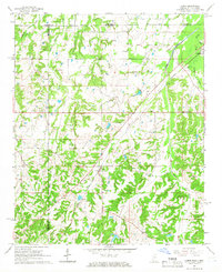
1965 Map of Lamar
USGS Topo · Published 1966About this map
The Illinois Central railroad serves as the primary spine for this Mississippi-Tennessee borderland, cutting diagonally through the countryside to connect Lamar and Michigan City. This mid-1960s survey reveals a landscape deeply connected to local genealogy and community life, marked by a high density of family and church-affiliated burial grounds. From the Hickory Hill Cem near the center of the sheet to the Hardaway Cem and Thompson Cem further south, these sites indicate long-established landholdings.
Find a feature on this map
38 named features on this map. Tap any name to fly to it.
Don’t see what you’re looking for? This feature index may not catch every label — zoom into the map to look around manually.
Map Details
Editions of this 1965 Lamar Map
2 editions found
Other maps of this area

1949 · Moscow
USGS Topo · 1:62,500

1950 · Ashland
USGS Topo · 1:62,500

1950 · Grand Junction
USGS Topo · 1:24,000

1951 · Grand Junction
USGS Topo · 1:24,000

1953 · Holly Springs
USGS Topo · 1:62,500

1956 · Blytheville
USGS Topo · 1:250,000

1956 · Tupelo
USGS Topo · 1:250,000

1958 · Tupelo
USGS Topo · 1:250,000

1959 · Blytheville
USGS Topo · 1:250,000

1964 · Holly Springs SE
USGS Topo · 1:24,000