1980s Maps of Dennis Landing, Mississippi
Explore 2 historic maps of Dennis Landing from the 1980s. These maps offer a rare glimpse into what life looked like during the 1980s — showing old roads, neighborhoods, homes, and landmarks that have changed or disappeared over time.
Whether you're researching your family's past, planning a metal detecting trip, or studying how Dennis Landing's landscape evolved across the 1980s, these high-resolution maps are a powerful tool for exploring the history of this region.
- Focus on a specific era: All maps on this page are from the 1980s, giving you a focused view of this time period.
- See what’s changed: Compare century-old streets, trails, and buildings to today's modern landscape using overlays and satellite layers.
- Research with precision: Use these maps for genealogy, historical research, land use analysis, or educational projects.
- View, download, or print: Maps are fully viewable online in high resolution, and can be downloaded or printed for your own records.
Start exploring Dennis Landing's history through authentic maps from the 1980s. This is your window into the past.
Dennis Landing, MS maps
(2)- 1982 Map of Laconia
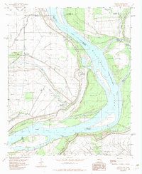 1982 Laconia1982 Print · USGSThe Arkansas-Mississippi borderlands along the great river are captured here in the early eighties. Researchers can trace family sites at Mt Pleasant Ch and Luke Cem, or locate riverside landmarks like Cessions Landing and Island No 69.
 - 1984 Map of Clarksdale, 1985 Print
 1984 Clarksdale1985 Print · USGSThe Mississippi Delta in the 1980s shows a landscape defined by its great river meanders and a dense network of bayous and rail lines. Researchers can trace the path of the Illinois Central Gulf through Clarksdale or locate river landmarks like Moon Lake and Friars Point.
End of results
Showing maps 1-2 of 2
Top cities near Dennis Landing
- Shelby historical maps
- Mound Bayou historical maps
- Rosedale historical maps
- Merigold historical maps
- Duncan historical maps
- Beulah historical maps
See more
Frequently asked questions
- What are the different types of historical maps available for Dennis Landing?
- What is the oldest map of Dennis Landing?
- Where can I purchase historical maps of Dennis Landing for my home or office?
- Where can I download high-res historical maps of Dennis Landing?
- Are there historical topographic maps available for Dennis Landing?
- Is there historical aerial imagery available for Dennis Landing?
- Where are historical maps of Dennis Landing sourced from?