1970s Maps of Eutaw, Mississippi
Explore 2 historic maps of Eutaw from the 1970s. These maps offer a rare glimpse into what life looked like during the 1970s — showing old roads, neighborhoods, homes, and landmarks that have changed or disappeared over time.
Whether you're researching your family's past, planning a metal detecting trip, or studying how Eutaw's landscape evolved across the 1970s, these high-resolution maps are a powerful tool for exploring the history of this region.
- Focus on a specific era: All maps on this page are from the 1970s, giving you a focused view of this time period.
- See what’s changed: Compare century-old streets, trails, and buildings to today's modern landscape using overlays and satellite layers.
- Research with precision: Use these maps for genealogy, historical research, land use analysis, or educational projects.
- View, download, or print: Maps are fully viewable online in high resolution, and can be downloaded or printed for your own records.
Start exploring Eutaw's history through authentic maps from the 1970s. This is your window into the past.
Eutaw, MS maps
(2)- 1972 Map of Catfish Point, 1974 Print
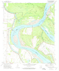 1972 Catfish Point1974 Print · USGSThe Mississippi River borderlands in the early 1970s reveal a landscape shaped by historical engineering and river navigation. Researchers can trace riverside locations like Lucca Landing and Eutaw Cem alongside the significant Caulk Cut-off.
 - 1977 Map of Lamont
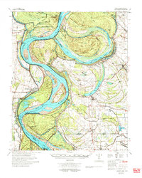 1977 Lamont1977 Print · USGSThe Mississippi Delta's shifting riverbanks and rural settlements are captured here in the late seventies. Genealogists and historians can trace community landmarks like Williams Chapel, the Nugent Center Sch, and the winding Lake Whittington oxbow.2 unique versions available
End of results
Showing maps 1-2 of 2
Top cities near Eutaw
- Greenville historical maps
- McGehee historical maps
- Rosedale historical maps
- Metcalfe historical maps
- Benoit historical maps
- Beulah historical maps
See more
Frequently asked questions
- What are the different types of historical maps available for Eutaw?
- What is the oldest map of Eutaw?
- Where can I purchase historical maps of Eutaw for my home or office?
- Where can I download high-res historical maps of Eutaw?
- Are there historical topographic maps available for Eutaw?
- Is there historical aerial imagery available for Eutaw?
- Where are historical maps of Eutaw sourced from?