1950s Maps of Bruce, Mississippi
Explore 5 historic maps of Bruce from the 1950s. These maps offer a rare glimpse into what life looked like during the 1950s — showing old roads, neighborhoods, homes, and landmarks that have changed or disappeared over time.
Whether you're researching your family's past, planning a metal detecting trip, or studying how Bruce's landscape evolved across the 1950s, these high-resolution maps are a powerful tool for exploring the history of this region.
- Focus on a specific era: All maps on this page are from the 1950s, giving you a focused view of this time period.
- See what’s changed: Compare century-old streets, trails, and buildings to today's modern landscape using overlays and satellite layers.
- Research with precision: Use these maps for genealogy, historical research, land use analysis, or educational projects.
- View, download, or print: Maps are fully viewable online in high resolution, and can be downloaded or printed for your own records.
Start exploring Bruce's history through authentic maps from the 1950s. This is your window into the past.
Bruce, MS maps
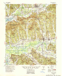
(5)- 1953 Map of West Point, 1973 Print
 1953 West Point1973 Print · USGSNorth-Central Mississippi and the Alabama borderlands are captured here during the mid-twentieth century as new reservoirs and national forests transformed the landscape. Researchers can trace the path of the Mississippi & Skuna Valley railroad or locate old landings along the Tombigbee River and Schooner Creek.3 unique versions available
 - 1954 Map of Pittsboro
 1954 Pittsboro1954 Print · USGSCalhoun County's river valleys and timberlands are captured here in the mid-fifties as the Grenada Reservoir took shape. Genealogists can locate family landmarks such as Zion Springs Ch & Cem, Worford Ch & Sch, and the Mississippi & Skuna Valley RR.3 unique versions available
 - 1956 Map of Tupelo, 1967 Print
 1956 Tupelo1967 Print · USGSNortheast Mississippi and parts of Tennessee and Alabama are shown here during the mid-fifties, a time of major reservoir construction and forestry management. Researchers can trace the St Louis-San Francisco RR through Tupelo or locate historic sites like Tishomingo State Park and the University.2 unique versions available
 - 1958 Map of Tupelo
 1958 Tupelo1958 Print · USGSNortheast Mississippi and neighboring Alabama and Tennessee appear here during the late fifties as a region defined by new reservoirs and historic rail lines. Genealogists can trace family locations near Sardis Lake, Woodall Mountain, and the St Louis-San Francisco Ry.
 - 1958 Map of West Point
 1958 West Point1958 Print · USGSNortheastern Mississippi and western Alabama are shown in the late 1950s, highlighting a region defined by its river-and-rail economy. Researchers can trace family roots through numerous settlements like Artesia and Vardaman or explore the corridor of the Tombigbee River.
End of results
Showing maps 1-5 of 5
Top cities near Bruce
- Calhoun City historical maps
- Derma historical maps
- Vardaman historical maps
- Pittsboro historical maps
- Big Creek historical maps
Frequently asked questions
- What are the different types of historical maps available for Bruce?
- What is the oldest map of Bruce?
- Where can I purchase historical maps of Bruce for my home or office?
- Where can I download high-res historical maps of Bruce?
- Are there historical topographic maps available for Bruce?
- Is there historical aerial imagery available for Bruce?
- Where are historical maps of Bruce sourced from?