1970s Maps of Collins, Mississippi
Explore 2 historic maps of Collins from the 1970s. These maps offer a rare glimpse into what life looked like during the 1970s — showing old roads, neighborhoods, homes, and landmarks that have changed or disappeared over time.
Whether you're researching your family's past, planning a metal detecting trip, or studying how Collins's landscape evolved across the 1970s, these high-resolution maps are a powerful tool for exploring the history of this region.
- Focus on a specific era: All maps on this page are from the 1970s, giving you a focused view of this time period.
- See what’s changed: Compare century-old streets, trails, and buildings to today's modern landscape using overlays and satellite layers.
- Research with precision: Use these maps for genealogy, historical research, land use analysis, or educational projects.
- View, download, or print: Maps are fully viewable online in high resolution, and can be downloaded or printed for your own records.
Start exploring Collins's history through authentic maps from the 1970s. This is your window into the past.
Collins, MS maps
(2)- 1974 Map of Williamsburg, 1978 Print
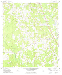 1974 Williamsburg1978 Print · USGSCovington County in the mid-1970s shows a landscape of creek-side settlements and rural industry before modern expansion. Genealogists can trace family names at Williamson Cem and Hameter Cem or locate community centers like Mt Beulah Ch.
 - 1974 Map of Collins, 1978 Print
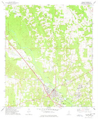 1974 Collins1978 Print · USGSCovington County shows a mix of rail-based industry and rural community life in the mid-seventies as the Illinois Central Gulf corridor shapes the landscape. Genealogists can trace family names through landmarks like Jones Chapel, Mt Zion Ch, and the Ora Cem.3 unique versions available
End of results
Showing maps 1-2 of 2
Top cities near Collins
- Magee historical maps
- Taylorsville historical maps
- Sumrall historical maps
- Mount Olive historical maps
- Seminary historical maps
- Bassfield historical maps
See more
Top neighborhoods of Collins
Frequently asked questions
- What are the different types of historical maps available for Collins?
- What is the oldest map of Collins?
- Where can I purchase historical maps of Collins for my home or office?
- Where can I download high-res historical maps of Collins?
- Are there historical topographic maps available for Collins?
- Is there historical aerial imagery available for Collins?
- Where are historical maps of Collins sourced from?