1990s Maps of Southaven, Mississippi
Explore 2 historic maps of Southaven from the 1990s. These maps offer a rare glimpse into what life looked like during the 1990s — showing old roads, neighborhoods, homes, and landmarks that have changed or disappeared over time.
Whether you're researching your family's past, planning a metal detecting trip, or studying how Southaven's landscape evolved across the 1990s, these high-resolution maps are a powerful tool for exploring the history of this region.
- Focus on a specific era: All maps on this page are from the 1990s, giving you a focused view of this time period.
- See what’s changed: Compare century-old streets, trails, and buildings to today's modern landscape using overlays and satellite layers.
- Research with precision: Use these maps for genealogy, historical research, land use analysis, or educational projects.
- View, download, or print: Maps are fully viewable online in high resolution, and can be downloaded or printed for your own records.
Start exploring Southaven's history through authentic maps from the 1990s. This is your window into the past.
Southaven, MS maps
(2)- 1990 Map of Helena, 1991 Print
 1990 Helena1991 Print · USGSThe Arkansas and Mississippi delta regions meet here in the 1990s, where the great river's oxbows and islands define the state line. Genealogists and historians can trace the rail networks of the Illinois Central Gulf RR and local settlements like Palestine, Marvell, and La Grange.
 - 1996 Map of Pleasant Hill, 2001 Print
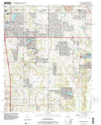 1996 Pleasant Hill2001 Print · USGSDeSoto County at the turn of the millennium shows the transition from rural crossroads to suburban expansion south of the state line. Genealogists and local historians can trace family locations near Pleasant Hill, Nesbitt, and the old Welch Sta.
End of results
Showing maps 1-2 of 2
Top cities near Southaven
- Memphis historical maps
- Germantown historical maps
- Olive Branch historical maps
- Horn Lake historical maps
- West Memphis historical maps
- Marion historical maps
See more
Top neighborhoods of Southaven
Frequently asked questions
- What are the different types of historical maps available for Southaven?
- What is the oldest map of Southaven?
- Where can I purchase historical maps of Southaven for my home or office?
- Where can I download high-res historical maps of Southaven?
- Are there historical topographic maps available for Southaven?
- Is there historical aerial imagery available for Southaven?
- Where are historical maps of Southaven sourced from?