1900s (20th Century) Maps of Edwards, Mississippi
Explore 7 historic maps of Edwards from the 1900s (20th Century). These maps offer a rare glimpse into what life looked like during the 1900s — showing old roads, neighborhoods, homes, and landmarks that have changed or disappeared over time.
Whether you're researching your family's past, planning a metal detecting trip, or studying how Edwards's landscape evolved across the 1900s, these high-resolution maps are a powerful tool for exploring the history of this region.
- Focus on a specific era: All maps on this page are from the 1900s, giving you a focused view of this time period.
- See what’s changed: Compare century-old streets, trails, and buildings to today's modern landscape using overlays and satellite layers.
- Research with precision: Use these maps for genealogy, historical research, land use analysis, or educational projects.
- View, download, or print: Maps are fully viewable online in high resolution, and can be downloaded or printed for your own records.
Start exploring Edwards's history through authentic maps from the 1900s. This is your window into the past.
Edwards, MS maps
(7)- 1938 Map of Edwards
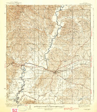 1938 Edwards1938 Print · USGSIn the late 1930s, the Hinds County countryside around Edwards was a dense network of rural schools and uniquely named churches. Trace the oxbows of the Big Black River to find landmarks like Mt Beulah College, Little Kingdom Come Ch, and Tomcat Island.3 unique versions available
 - 1955 Map of Jackson
 1955 Jackson1955 Print · USGSThe Lower Mississippi Valley at the middle of the century reveals a landscape of deep river meanders and growing rail hubs. Genealogists and historians can trace the mid-century footprints of Vicksburg National Military Park, old river landings at Port Gibson, and the rail corridors of the Illinois Central Railroad.3 unique versions available
 - 1961 Map of Jackson
 1961 Jackson1961 Print · USGSThe Lower Mississippi Delta and the state capital area are captured here during the post-war era of infrastructure expansion. Researchers can trace the complex river oxbows and rail lines connecting Vicksburg, Yazoo City, and the Illinois Central Railroad network.
 - 1962 Map of Jackson
 1962 Jackson1962 Print · USGSThe Mississippi Delta and the state capital region are mapped here in the early sixties, showing a landscape defined by the great river and the growing city of JACKSON. Genealogists can trace family roots through numerous landmarks like Cedar Hill Cem, rural stops on the Illinois Central RR, and historic sites like Champion Hill.2 unique versions available
 - 1972 Map of Edwards, 1974 Print
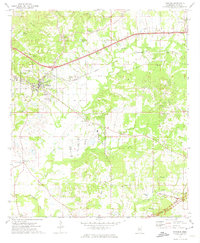 1972 Edwards1974 Print · USGSHinds County in the early seventies centers on the town of Edwards and the high ground of Champion Hill during a period of steady rural continuity. Genealogists can trace family-named landmarks and old congregations like Pilgrim Rest Ch, Mt Moriah Ch, and the Ratliff Chapel Cem.3 unique versions available
 - 1975 Map of Edwards, 1976 Print
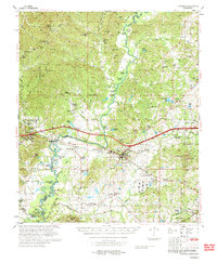 1975 Edwards1976 Print · USGSCentral Mississippi in the mid-seventies shows a landscape of river-bottom farms and rail towns along the Illinois Central Gulf. Genealogists can trace family names through landmarks like Neely Cem, Taylor Cem, and the site of Mt Beulah College.
 - 1984 Map of Jackson
 1984 Jackson1984 Print · USGSCentral Mississippi in the mid-eighties shows a landscape defined by the growing suburbs of Jackson and the riverfront legacy of Vicksburg. Researchers can trace the Natchez Trace Parkway or locate local landmarks like Utica College and Mississippi State Hospital.
End of results
Showing maps 1-7 of 7
Top cities near Edwards
- Clinton historical maps
- Vicksburg historical maps
- Raymond historical maps
- Utica historical maps
- Bolton historical maps
- Learned historical maps
Frequently asked questions
- What are the different types of historical maps available for Edwards?
- What is the oldest map of Edwards?
- Where can I purchase historical maps of Edwards for my home or office?
- Where can I download high-res historical maps of Edwards?
- Are there historical topographic maps available for Edwards?
- Is there historical aerial imagery available for Edwards?
- Where are historical maps of Edwards sourced from?