1900s (20th Century) Maps of Hopedale, Mississippi
Explore 10 historic maps of Hopedale from the 1900s (20th Century). These maps offer a rare glimpse into what life looked like during the 1900s — showing old roads, neighborhoods, homes, and landmarks that have changed or disappeared over time.
Whether you're researching your family's past, planning a metal detecting trip, or studying how Hopedale's landscape evolved across the 1900s, these high-resolution maps are a powerful tool for exploring the history of this region.
- Focus on a specific era: All maps on this page are from the 1900s, giving you a focused view of this time period.
- See what’s changed: Compare century-old streets, trails, and buildings to today's modern landscape using overlays and satellite layers.
- Research with precision: Use these maps for genealogy, historical research, land use analysis, or educational projects.
- View, download, or print: Maps are fully viewable online in high resolution, and can be downloaded or printed for your own records.
Start exploring Hopedale's history through authentic maps from the 1900s. This is your window into the past.
Hopedale, MS maps
(10)- 1909 Map of Wilsons Point
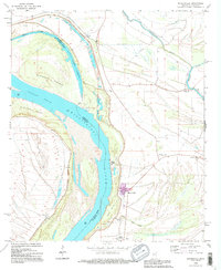
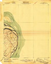 1909 Wilsons Point1909 Print · USGSEast Carroll Parish at the height of the river trade era reveals a landscape of alluvial points and levee-protected settlements. Genealogists and researchers can trace land tracts near Wilsons Point, the Morning Star Church, and the riverfront at Cottonwood.2 unique versions available
 - 1913 Map of Wilson Point
 1913 Wilson Point1913 Print · USGSEast Carroll Parish at the height of the levee-building era shows a landscape defined by the shifting banks of the Mississippi River. Researchers can trace the riverfront settlements at Wilson Point and Cottonwood, or locate the Morning Star Church near the water.
 - 1939 Map of Mayersville, 1964 Print
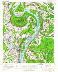 1939 Mayersville1964 Print · USGSThe Mississippi River meanders between Louisiana and Mississippi in the late 1930s, showing a landscape defined by dramatic cut-offs and levee engineering. Genealogists and researchers can locate landmarks like Rose Hall, the Indian Mound, and rural congregations at Mt Olive Ch.
 - 1955 Map of Jackson
 1955 Jackson1955 Print · USGSThe Lower Mississippi Valley at the middle of the century reveals a landscape of deep river meanders and growing rail hubs. Genealogists and historians can trace the mid-century footprints of Vicksburg National Military Park, old river landings at Port Gibson, and the rail corridors of the Illinois Central Railroad.3 unique versions available
 - 1961 Map of Jackson
 1961 Jackson1961 Print · USGSThe Lower Mississippi Delta and the state capital area are captured here during the post-war era of infrastructure expansion. Researchers can trace the complex river oxbows and rail lines connecting Vicksburg, Yazoo City, and the Illinois Central Railroad network.
 - 1962 Map of Jackson
 1962 Jackson1962 Print · USGSThe Mississippi Delta and the state capital region are mapped here in the early sixties, showing a landscape defined by the great river and the growing city of JACKSON. Genealogists can trace family roots through numerous landmarks like Cedar Hill Cem, rural stops on the Illinois Central RR, and historic sites like Champion Hill.2 unique versions available
 - 1970 Map of Mayersville, 1972 Print
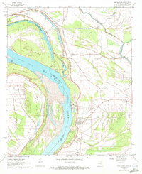 1970 Mayersville1972 Print · USGSMayersville and the lower Delta floodplain are captured in the early seventies, dominated by the massive river bends and protective levees. Researchers can trace local genealogy and land use through features like New Bethel Ch, the Indian Mounds, and rural settlements like Addie and Cottonwood.3 unique versions available
 - 1972 Map of Lake Providence
 1972 Lake Providence1972 Print · USGSThe Mississippi River delta in the early 1970s reveals a landscape of complex oxbows and river engineering between Louisiana and Mississippi. Genealogists can locate family landmarks like Old St Paul Cem, Briarfield Academy, and the Missouri Pacific rail line.
 - 1982 Map of Bastrop, 1983 Print
 1982 Bastrop1983 Print · USGSNortheastern Louisiana and the Mississippi River Delta are captured here in the early eighties as a landscape of bayous and river towns. Genealogists and historians can trace small communities like Mer Rouge and Oak Grove or the ancient terrain of Poverty Point State Park.
 - 1994 Map of Mayersville, 1995 Print
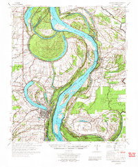
 1994 Mayersville1995 Print · USGSThe Mississippi River delta near the turn of the millennium reveals a complex landscape of shifting chutes and ancient earthworks. Genealogists and historians can trace local life at Mayersville through the New Bethel Cem Ch, Issaquena Sch, and the nearby Indian Mounds.
End of results
Showing maps 1-10 of 10
Top cities near Hopedale
- Lake Providence historical maps
- Hollandale historical maps
- Rolling Fork historical maps
- Anguilla historical maps
- Mayersville historical maps
- Cary historical maps
Frequently asked questions
- What are the different types of historical maps available for Hopedale?
- What is the oldest map of Hopedale?
- Where can I purchase historical maps of Hopedale for my home or office?
- Where can I download high-res historical maps of Hopedale?
- Are there historical topographic maps available for Hopedale?
- Is there historical aerial imagery available for Hopedale?
- Where are historical maps of Hopedale sourced from?