1970s Maps of Jasper County, Mississippi
Explore 6 historic maps of Jasper County from the 1970s. These maps offer a rare glimpse into what life looked like during the 1970s — showing old roads, neighborhoods, homes, and landmarks that have changed or disappeared over time.
Whether you're researching your family's past, planning a metal detecting trip, or studying how Jasper County's landscape evolved across the 1970s, these high-resolution maps are a powerful tool for exploring the history of this region.
- Focus on a specific era: All maps on this page are from the 1970s, giving you a focused view of this time period.
- See what’s changed: Compare century-old streets, trails, and buildings to today's modern landscape using overlays and satellite layers.
- Research with precision: Use these maps for genealogy, historical research, land use analysis, or educational projects.
- View, download, or print: Maps are fully viewable online in high resolution, and can be downloaded or printed for your own records.
Start exploring Jasper County's history through authentic maps from the 1970s. This is your window into the past.
Jasper County, MS maps
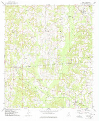
(6)- 1970 Map of Paulding, 1972 Print
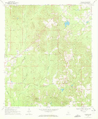 1970 Paulding1972 Print · USGSJasper County in the early seventies shows a landscape of small rural settlements and an emerging energy industry. Researchers can trace family sites at Little Rocky Mount Ch or locate historical petroleum operations at several Oil Wells and a Pumping Sta.2 unique versions available
 - 1970 Map of Hero, 1972 Print
 1970 Hero1972 Print · USGSThe border of Jasper and Newton Counties comes into focus during the early 1970s, showing a landscape of rural communities and winding creeks. Genealogists can trace local landmarks like Garlandville, Hickory Grove Cem, and churches such as Mt Vernon Ch.2 unique versions available
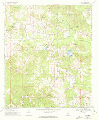
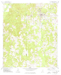
 - 1970 Map of Montrose North, 1972 Print
 1970 Montrose North1972 Print · USGSJasper and Newton counties in the early 1970s remained a region of timbered hills and quiet railroad junctions. Researchers can trace the Gulf Mobile and Ohio line past Garlandville or locate family sites at Sand Ridge Church and the Pilgrim Rest Ch Cemeteries.2 unique versions available
 - 1970 Map of Montrose South, 1972 Print
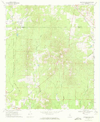
 1970 Montrose South1972 Print · USGSJasper County in the early seventies shows a rural landscape of timberland and creekside settlements just before modern development. Genealogists can trace family footprints through numerous sites like St Paul Cem, McNeal, and the Antioch Cem.
 - 1974 Map of Soso, 1978 Print
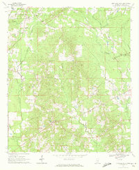
 1974 Soso1978 Print · USGSThe borderlands of Smith, Jasper, and Jones Counties are captured in the mid-1970s as the regional oil and gas industry matured. Trace old family sites and rural landmarks like Gitano, Knights Mill Cem, and Knight Cem Ch along the Illinois Central Gulf line.
 - 1974 Map of Bay Springs, 1978 Print
 1974 Bay Springs1978 Print · USGSMississippi's Pine Belt is captured in the mid-seventies, showing the growth of Bay Springs alongside the Bay Springs Oil and Gas Field. Genealogists and historians can locate numerous rural landmarks like Mt Nebo Ch, Sylva-Bay Academy, and the Taylorsville Lookout Tower.
End of results
Showing maps 1-6 of 6
Top cities of Jasper County
Frequently asked questions
- What are the different types of historical maps available for Jasper County?
- What is the oldest map of Jasper County?
- Where can I purchase historical maps of Jasper County for my home or office?
- Where can I download high-res historical maps of Jasper County?
- Are there historical topographic maps available for Jasper County?
- Is there historical aerial imagery available for Jasper County?
- Where are historical maps of Jasper County sourced from?