1980s Maps of Moseley, Mississippi
Explore 2 historic maps of Moseley from the 1980s. These maps offer a rare glimpse into what life looked like during the 1980s — showing old roads, neighborhoods, homes, and landmarks that have changed or disappeared over time.
Whether you're researching your family's past, planning a metal detecting trip, or studying how Moseley's landscape evolved across the 1980s, these high-resolution maps are a powerful tool for exploring the history of this region.
- Focus on a specific era: All maps on this page are from the 1980s, giving you a focused view of this time period.
- See what’s changed: Compare century-old streets, trails, and buildings to today's modern landscape using overlays and satellite layers.
- Research with precision: Use these maps for genealogy, historical research, land use analysis, or educational projects.
- View, download, or print: Maps are fully viewable online in high resolution, and can be downloaded or printed for your own records.
Start exploring Moseley's history through authentic maps from the 1980s. This is your window into the past.
Moseley, MS maps
(2)- 1983 Map of Collinsville
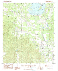 1983 Collinsville1983 Print · USGSLauderdale County is shown here in the early eighties as the waters of Okatibbee Lake shaped the local landscape. Genealogists can trace family roots through several rural settlements and landmarks like Sharp Mem Sch, Nellieburg, and the Cedar Grove Cem.
 - 1984 Map of Meridian
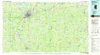 1984 Meridian1984 Print · USGSEastern Mississippi and Western Alabama come alive in the mid-1980s, showing the expansion of Meridian and the surrounding timber and river lands. Genealogists and researchers can trace family landmarks like Memorial Park Cem, the Pine Springs church, and the rural roads near Kewanee.3 unique versions available
End of results
Showing maps 1-2 of 2
Top cities near Moseley
Frequently asked questions
- What are the different types of historical maps available for Moseley?
- What is the oldest map of Moseley?
- Where can I purchase historical maps of Moseley for my home or office?
- Where can I download high-res historical maps of Moseley?
- Are there historical topographic maps available for Moseley?
- Is there historical aerial imagery available for Moseley?
- Where are historical maps of Moseley sourced from?