1960s Maps of Camden, Mississippi
Explore 3 historic maps of Camden from the 1960s. These maps offer a rare glimpse into what life looked like during the 1960s — showing old roads, neighborhoods, homes, and landmarks that have changed or disappeared over time.
Whether you're researching your family's past, planning a metal detecting trip, or studying how Camden's landscape evolved across the 1960s, these high-resolution maps are a powerful tool for exploring the history of this region.
- Focus on a specific era: All maps on this page are from the 1960s, giving you a focused view of this time period.
- See what’s changed: Compare century-old streets, trails, and buildings to today's modern landscape using overlays and satellite layers.
- Research with precision: Use these maps for genealogy, historical research, land use analysis, or educational projects.
- View, download, or print: Maps are fully viewable online in high resolution, and can be downloaded or printed for your own records.
Start exploring Camden's history through authentic maps from the 1960s. This is your window into the past.
Camden, MS maps
(3)- 1964 Map of Camden, 1965 Print
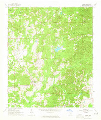 1964 Camden1965 Print · USGSMadison County's rural communities are meticulously recorded in the mid-1960s, showing the intersection of local history and old land boundaries. Researchers can trace the Old Treaty Boundary and locate family landmarks like Shiloh Cem and Mt Mary Ch.3 unique versions available
 - 1965 Map of Meridian
 1965 Meridian1965 Print · USGSEast Mississippi and West Alabama are mapped here in the mid-sixties as the region's modern highway and reservoir systems began to take shape. Researchers can trace rural lineages through local landmarks like Prince Chapel and Tuscahoma Landing, or follow the historic Gulf Mobile & Ohio rail lines.
 - 1966 Map of Goodman, 1967 Print
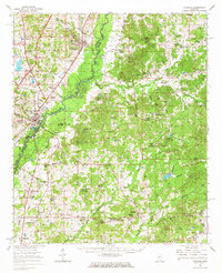 1966 Goodman1967 Print · USGSMid-century Mississippi hill country and river bottomlands come alive here in the mid-1960s as small farming communities and timberlands span four counties. Genealogists can trace family roots through dozen of rural landmarks like Soule Chapel, Quiet Ridge Cem, and the Holmes County Junior College.
End of results
Showing maps 1-3 of 3
Top cities near Camden
Frequently asked questions
- What are the different types of historical maps available for Camden?
- What is the oldest map of Camden?
- Where can I purchase historical maps of Camden for my home or office?
- Where can I download high-res historical maps of Camden?
- Are there historical topographic maps available for Camden?
- Is there historical aerial imagery available for Camden?
- Where are historical maps of Camden sourced from?