1990s Maps of Industrial, Mississippi
Explore 2 historic maps of Industrial from the 1990s. These maps offer a rare glimpse into what life looked like during the 1990s — showing old roads, neighborhoods, homes, and landmarks that have changed or disappeared over time.
Whether you're researching your family's past, planning a metal detecting trip, or studying how Industrial's landscape evolved across the 1990s, these high-resolution maps are a powerful tool for exploring the history of this region.
- Focus on a specific era: All maps on this page are from the 1990s, giving you a focused view of this time period.
- See what’s changed: Compare century-old streets, trails, and buildings to today's modern landscape using overlays and satellite layers.
- Research with precision: Use these maps for genealogy, historical research, land use analysis, or educational projects.
- View, download, or print: Maps are fully viewable online in high resolution, and can be downloaded or printed for your own records.
Start exploring Industrial's history through authentic maps from the 1990s. This is your window into the past.
Industrial, MS maps
(2)- 1994 Map of Bogalusa
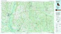 1994 Bogalusa1994 Print · USGSThe timber country and river bottoms of the Louisiana-Mississippi borderlands come alive in the mid-nineties. Genealogists and researchers can trace the rail-and-river geography of Bogalusa, the winding Pearl River, and family settlements like McNeill and Varnado.2 unique versions available
 - 1997 Map of Industrial, 1999 Print
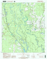 1997 Industrial1999 Print · USGSThe Pearl River bottomlands at the Mississippi-Louisiana line appear here in the late nineties as a complex maze of bayous and islands. Researchers can locate family burial sites like Carpenter Cem and Parker Cem or trace the early paths of Stewart Road and Walkiah Road.
End of results
Showing maps 1-2 of 2
Top cities near Industrial
Frequently asked questions
- What are the different types of historical maps available for Industrial?
- What is the oldest map of Industrial?
- Where can I purchase historical maps of Industrial for my home or office?
- Where can I download high-res historical maps of Industrial?
- Are there historical topographic maps available for Industrial?
- Is there historical aerial imagery available for Industrial?
- Where are historical maps of Industrial sourced from?