Old Maps of Bogalusa, Louisiana
Explore 35 old maps of Bogalusa, spanning from 1942 to today. These high-resolution historic maps reveal how streets, neighborhoods, landmarks, and natural features evolved over time — perfect for genealogy, metal detecting, research, and local history exploration.
What you can do with these maps:
- See how Bogalusa changed over time: Compare historical maps to modern-day views to trace roads, homesites, rail lines & more.
- View detailed metadata: Each map includes creators, publishers, year, scale, and archive source.
- Overlay maps with satellite & LiDAR: Visualize the past alongside modern tools to explore terrain & human change.
- Trusted historical sources: Maps sourced from the USGS, Library of Congress, and other archives.
- Access maps your way: View online, download high-res files, or order prints for personal or research use.
Start exploring old maps of Bogalusa to uncover forgotten places, hidden landmarks, and the deep history beneath your feet.
Bogalusa, LA maps
(35)- 1942 Map of Pools Bluff
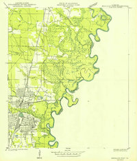
 1942 Pools Bluff1942 Print · USGSThe Pearl River bottomlands at the start of the 1940s reveal a landscape of dense bayous and isolated river settlements. Genealogists can locate family burial grounds like Sheridan Cem and Morris Cem, or trace early transit routes such as the Float Road.
 - 1949 Map of Bogalusa East
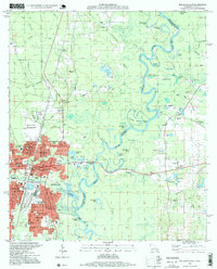
 1949 Bogalusa East1949 Print · USGSThe industrial city of Bogalusa sits at the edge of the Pearl River bottomlands in the late 1940s. Researchers can trace the city's growth from Goodyear Park to the Gulf Mobile and Ohio rail lines, or locate family plots at Gann Cem and Adams Cem.
 - 1949 Map of Bogalusa West
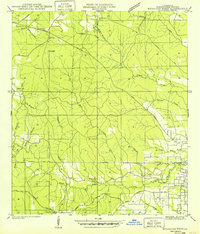 1949 Bogalusa West1949 Print · USGSThe piney woods of Washington Parish appear here in the decade following the Great Depression, showing a landscape shaped by timber and small communities. Researchers can locate family burial grounds like Mc Ghee Cem, the Ben Ford Sch, and the Sheridan Fire Tower.
 - 1953 Map of Mobile, 1968 Print
 1953 Mobile1968 Print · USGSThe Gulf Coast comes alive in this mid-century survey, from the streets of Mobile to the marshes of New Orleans. Trace family roots in coastal towns like Pass Christian and Bayou La Batre or locate military landmarks including Keesler AFB.3 unique versions available
 - 1957 Map of Mobile
 1957 Mobile1957 Print · USGSThe Gulf Coast in the mid-1950s reveals a bustling corridor of rail-and-river commerce connecting Alabama to Louisiana. Genealogists and historians can trace old settlements and military hubs from Keesler Afb to the coastal reaches of Ship Island and Bogalusa.3 unique versions available
 - 1959 Map of Bogalusa, 1960 Print
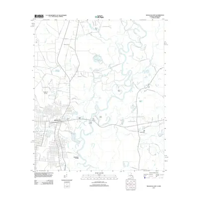
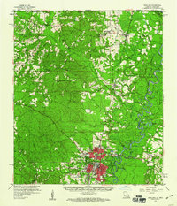 1959 Bogalusa1960 Print · USGSThe Pearl River valley and the industrial hub of Bogalusa are captured here in the late fifties. Genealogists can trace family names through dozens of rural sites like Mitchells Chapel, Old Live Oak Cem, and the Buck Branch School.2 unique versions available
 - 1960 Map of Mobile
 1960 Mobile1960 Print · USGSThe Gulf Coast at the dawn of the sixties shows a landscape of busy ports, military airbases, and barrier islands. Trace the rail lines of the Louisville & Nashville through BILOXI and Pascagoula or find family history in towns like Bayou La Batre and Poplarville.
 - 1961 Map of Sun, 1963 Print
 1961 Sun1963 Print · USGSLife along the Louisiana and Mississippi border centered on the river and the rail in the early sixties. Researchers can trace family history through dozens of rural landmarks like Byrds Chapel, Rio, and the Gulf Mobile and Ohio line.3 unique versions available
 - 1963 Map of Mobile
 1963 Mobile1963 Print · USGSThe Gulf Coast at the dawn of the sixties shows a thriving maritime and military corridor from Louisiana to Alabama. Genealogists and historians can trace rail lines like the Louisville & Nashville RR and find landmarks from Brookley AFB to Fort Morgan.
 - 1965 Map of Mobile
 1965 Mobile1965 Print · USGSThe Gulf Coast at mid-century reveals a landscape of expanding ports and vital military installations from Louisiana to Alabama. Genealogists and historians can trace the growth of Biloxi, Pascagoula, and Mobile, alongside the sprawling De Soto National Forest.
 - 1976 Map of Bogalusa SE, 1977 Print
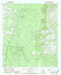
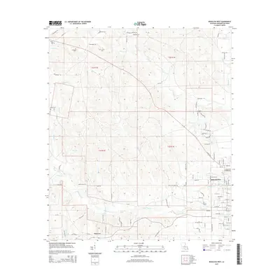
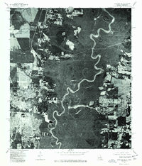 1976 Bogalusa SE1977 Print · USGSThe industrial edge of Bogalusa and the dense swamp forests of the Mississippi border are shown here during the mid-seventies. Researchers can trace the development of Bogalusa and the dramatic, twisting course of the Pearl River.
 - 1976 Map of Sun NE, 1977 Print
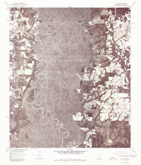 1976 Sun NE1977 Print · USGSThe borderlands between Mississippi and Louisiana appear in sharp detail in the mid-1970s. Trace the winding course of the Pearl River and the rural roads near Henleyfield and Lees Creek.
 - 1976 Map of Bogalusa SW, 1977 Print
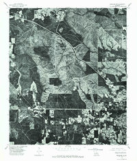 1976 Bogalusa SW1977 Print · USGSThe timber country and northern fringes of the paper-mill town appear in sharp detail just after the mid-seventies. Local historians can trace the expanding residential footprint and industrial layout around Bogalusa through this precise photographic survey.
 - 1982 Map of Bogalusa West
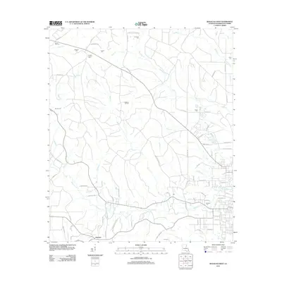
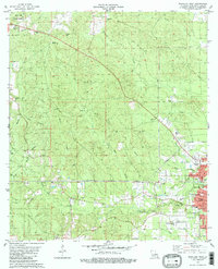 1982 Bogalusa West1982 Print · USGSThe growing city of Bogalusa and the rural reaches of Washington Parish are captured here in the early eighties. Researchers can trace family history through local sites like the Denhamtown School, Sheridan Lookout Tower, and Plainview Cemetery.2 unique versions available
 - 1982 Map of Bogalusa East
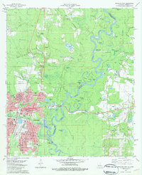 1982 Bogalusa East1982 Print · USGSBogalusa sits at the confluence of industry and nature in the early eighties as the Pearl River meanders along the state line. Genealogists can trace family names at Ponemah Cemetery, Miley Cem, and the rural crossing at Piggott Crossing.2 unique versions available
 - 1983 Map of Henleyfield, 1984 Print
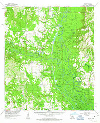
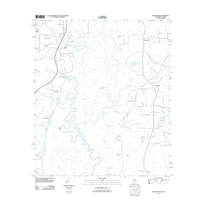
 1983 Henleyfield1984 Print · USGSThe Pearl River and Bogue Chitto bottomlands are captured here in the early 1980s. Genealogists can trace family names at Henleyfield Cem and Sheridan Cem, while outdoor historians can locate Hells Gate and Lock No 3.2 unique versions available
 - 1984 Map of Bogalusa
 1984 Bogalusa1984 Print · USGSThe Pearl River basin on the Louisiana-Mississippi border comes into focus in the mid-1980s, showcasing a landscape of river-bottom swamps and timberlands. Local researchers can trace the growth of Bogalusa and Picayune or find rural landmarks like Macedonia Ch and Wheat Swamp.
 - 1984 Map of Mobile
 1984 Mobile1984 Print · USGSThe Gulf Coast at the height of the mid-eighties shows a landscape of rapid industrial growth and military significance. Researchers can trace the sprawling rail lines of the Illinois Central Gulf RR, locate the NASA Test Facility, or study the barrier island chain from Cat Island to Petit Bois Island.3 unique versions available
 - 1994 Map of Bogalusa
 1994 Bogalusa1994 Print · USGSThe timber country and river bottoms of the Louisiana-Mississippi borderlands come alive in the mid-nineties. Genealogists and researchers can trace the rail-and-river geography of Bogalusa, the winding Pearl River, and family settlements like McNeill and Varnado.2 unique versions available
 - 1997 Map of Bogalusa East, 1999 Print
 1997 Bogalusa East1999 Print · USGSBogalusa and the Pearl River corridor are shown late in the twentieth century, bridging the Louisiana-Mississippi border. Genealogists and historians can locate numerous family-named sites, including Miley Cem, Piggott Crossing, and the Sullivan Voc-Tech Inst.
 - 2012 Map of Bogalusa West, 2012 Print
 2012 Bogalusa West2012 Print · USGSCovers Bogalusa, including Plainview, Washington Parish, and other nearby areas
 - 2012 Map of Bogalusa East, 2012 Print
 2012 Bogalusa East2012 Print · USGSCovers Bogalusa, including Richardson Landing, Crossroads, and other nearby areas
 - 2012 Map of Henleyfield, 2012 Print
 2012 Henleyfield2012 Print · USGSCovers Bogalusa, including Cybur, Henleyfield, and other nearby areas
 - 2015 Map of Bogalusa East, 2015 Print
 2015 Bogalusa East2015 Print · USGSCovers Bogalusa, including Richardson Landing, Crossroads, and other nearby areas
 - 2015 Map of Bogalusa West, 2015 Print
 2015 Bogalusa West2015 Print · USGSCovers Bogalusa, including Plainview, Washington Parish, and other nearby areas
Showing maps 1-25 of 35
Top cities near Bogalusa
Frequently asked questions
- What are the different types of historical maps available for Bogalusa?
- What is the oldest map of Bogalusa?
- Where can I purchase historical maps of Bogalusa for my home or office?
- Where can I download high-res historical maps of Bogalusa?
- Are there historical topographic maps available for Bogalusa?
- Is there historical aerial imagery available for Bogalusa?
- Where are historical maps of Bogalusa sourced from?