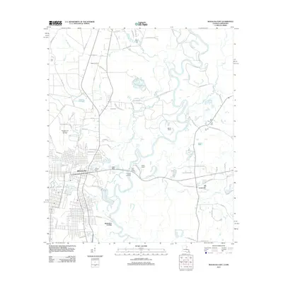
2012 Map of Bogalusa East
USGS Topo · Published 2012About this map
Bogalusa serves as the focal point for this survey, showcasing a landscape defined by its connection to the winding Pearl River. The city's grid extends toward the riverbanks, where geographic features like Peters Island and Hamp Island interrupt the waterway's course. Infrastructure such as the Pearl River Bridge and the Crossroads Landing Boat Ramp emphasize the river's role in local transport and recreation. To the west of the main settlement, the George R Carr Memorial Air Field sits near industrial developments, while numerous cemeteries including Ponemah Cem and Miley Cem are scattered throughout the region. The map also captures smaller peripheral communities and landmarks like Lake View and Piggott Crossing, alongside an intricate network of waterways including Bogue Lusa Cr, Coburn Cr, and Pushepatapa Cr. This documentation provides a clear view of the area's development, balancing established residential blocks with the natural drainage patterns of the coastal plain.
Find a feature on this map
96 named features on this map. Tap any name to fly to it.
Don’t see what you’re looking for? This feature index may not catch every label — zoom into the map to look around manually.
Map Details
Editions of this 2012 Bogalusa East Map
This is the sole edition of this map. No revisions or reprints were ever made.
Other maps of this area

1942 · Rio
USGS Topo · 1:31,680

1942 · Pools Bluff
USGS Topo · 1:31,680

1949 · Bogalusa East
USGS Topo · 1:31,680

1949 · Angie
USGS Topo · 1:31,680

1949 · Bogalusa West
USGS Topo · 1:31,680

1950 · Crains Creek
USGS Topo · 1:31,680

1953 · Mobile
USGS Topo · 1:250,000

1957 · Mobile
USGS Topo · 1:250,000

1958 · Picayune
USGS Topo · 1:62,500

1959 · Bogalusa
USGS Topo · 1:62,500