1942 Map of Rio
USGS Topo · Published 1942About this map
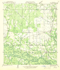
The Bogue Chitto River meanders through the southern half of this landscape, its path defined by complex waterways like Dead Lake, Sandy Slough, and Crooked Bayou. During this era in the early 1940s, the rural border between Washington Parish and St Tammany Parish was a network of small settlements and family landmarks. The Gulf Mobile and Ohio railroad serves as a central artery, passing through Rio and past Stein. Genealogy interests are well-served by numerous burial grounds, including the Old Magee Cem, Galloway Cem, and Reviere Cem. Education and faith centers like the Rosenwald Sch, Isabel Sch, and Jerusalem Ch anchor the community, while the landscape shows evidence of local industry at the Old Gravel Pits near the riverbanks.
Find a feature on this map
59 named features on this map. Tap any name to fly to it.
Don’t see what you’re looking for? This feature index may not catch every label — zoom into the map to look around manually.
Map Details
Editions of this 1942 Rio Map
This is the sole edition of this map. No revisions or reprints were ever made.
Historical Maps of Sun Through Time
1 maps found