
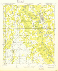
1939 Map of Zona
USGS Topo · Published 1939About this map
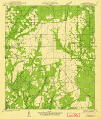
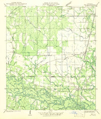
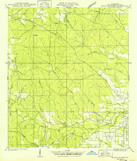
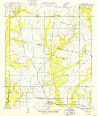
The Bogue Chitto River winds through the heart of this 1939 survey, marking the rural landscape of the Washington and St. Tammany Parish border. At this time, the settlements of Zona and Enon served as local hubs, connected by a network of state highways and country roads. The map reveals a deeply rooted community, documented through numerous family burial grounds such as Magee Cem, Mizell Cem, and Sharp Cem. Educational and spiritual life is anchored by sites like Shady Grove Sch and Sharps Chapel. Notable aviation and forestry infrastructure of the era is present, including an Airway Beacon near Enon and a Fire Tower to the west. The terrain is defined by a dense system of waterways, including Thigpen Creek, Mulatto Branch, and the Little Bogue Falaya River, illustrating the importance of natural drainage to the local geography.
Find a feature on this map
42 named features on this map. Tap any name to fly to it.
Don’t see what you’re looking for? This feature index may not catch every label — zoom into the map to look around manually.
Map Details
Editions of this 1939 Zona Map
This is the sole edition of this map. No revisions or reprints were ever made.
Other maps of this area

1942 · Onville
USGS Topo · 1:31,680

1942 · Waldheim
USGS Topo · 1:31,680
1942 · Thigpen
USGS Topo · 1:31,680

1942 · Talisheek
USGS Topo · 1:31,680
1942 · Rio
USGS Topo · 1:31,680
1949 · Bogalusa West
USGS Topo · 1:31,680
1950 · Folsom
USGS Topo · 1:31,680
1950 · Franklinton
USGS Topo · 1:31,680

1953 · Mobile
USGS Topo · 1:250,000
1954 · Folsom
USGS Topo · 1:62,500