
1953 Map of Mobile
USGS Topo · Published 1968About this map
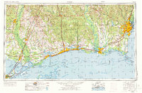
The Central Gulf Coast is mapped here in the early 1950s, detailing the maritime and military infrastructure of Mobile and Biloxi before the massive expansion of the modern interstate system. The landscape is defined by the proximity of the De Soto National Forest and the strategic positioning of Keesler AFB and Brookley AFB. Along the Mississippi Sound, a string of coastal settlements including Pass Christian, Gulfport, and Ocean Springs are connected by U S Highway 90, while the barrier islands like Ship Island and Dauphin Island protect the inner bays. To the west, the map reaches the industrial fringes of New Orleans at Lake Pontchartrain, illustrating a complex network of bayous and marshes such as Bayou La Batre and Lake Borgne that supported the region's historical fishing and shipping economies.
Find a feature on this map
241 named features on this map. Tap any name to fly to it.
Don’t see what you’re looking for? This feature index may not catch every label — zoom into the map to look around manually.
Map Details
Editions of this 1953 Mobile Map
3 editions found
Other maps of this area

1891 · Spanish Fort
USGS Topo · 1:62,500

1891 · New Orleans
USGS Topo · 1:62,500

1892 · Chef Menteur
USGS Topo · 1:62,500

1892 · St. Bernard
USGS Topo · 1:62,500

1893 · Cat Island
USGS Topo · 1:62,500

1893 · Rigolets
USGS Topo · 1:62,500

1893 · Chandeleur
USGS Topo · 1:62,500

1893 · Shell Beach
USGS Topo · 1:62,500

1893 · Toulme
USGS Topo · 1:62,500

1895 · Bodreau
USGS Topo · 1:62,500