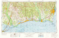
1953 Map of Mobile
USGS Topo · Published 1973About this map
The Gulf Coast coastline from New Orleans to Mobile reveals an era of significant federal and industrial expansion during the mid-20th century. Large-scale government installations like the Mississippi Test Facility (NASA) and the Michoud Assembly Facility (NASA) underscore the region's importance to the space race. The landscape is defined by the complex waterways of the Mississippi Sound and Mobile Bay, protected by a chain of barrier islands including Cat Island, Ship Island, and Dauphin Island. Inland, the De Soto National Forest covers much of the northern terrain, while the coastal economy is bridged by the Gulf Mobile & Ohio and Louisville & Nashville railroads. This survey provides a look at the established fishing communities and port towns like Bayou La Batre and Pascagoula before modern coastal development reshaped the shoreline.
Find a feature on this map
70 named features on this map. Tap any name to fly to it.
Don’t see what you’re looking for? This feature index may not catch every label — zoom into the map to look around manually.
Map Details
Editions of this 1953 Mobile Map
3 editions found

Other maps of this area

1891 · Spanish Fort
USGS Topo · 1:62,500

1891 · New Orleans
USGS Topo · 1:62,500

1892 · Chef Menteur
USGS Topo · 1:62,500

1892 · St. Bernard
USGS Topo · 1:62,500

1893 · Cat Island
USGS Topo · 1:62,500

1893 · Rigolets
USGS Topo · 1:62,500

1893 · Chandeleur
USGS Topo · 1:62,500

1893 · Shell Beach
USGS Topo · 1:62,500

1893 · Toulme
USGS Topo · 1:62,500

1895 · Bodreau
USGS Topo · 1:62,500