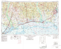
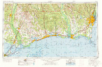
1953 Map of Mobile
USGS Topo · Published 1980About this map
Pearl River and the sweeping coastline of the Gulf of Mexico anchor this expansive 1950s study of the Deep South, updated to show the early decades of the space age and the deepening maritime infrastructure of the region. The map charts the established rail networks of the Louisville & Nashville and Gulf Mobile & Ohio railroads as they connect industrial hubs like Mobile and Gulfport to smaller communities such as Bayou La Batre and Poplarville.
Find a feature on this map
69 named features on this map. Tap any name to fly to it.
Don’t see what you’re looking for? This feature index may not catch every label — zoom into the map to look around manually.
Map Details
Editions of this 1953 Mobile Map
3 editions found

Other maps of this area

1891 · Spanish Fort
USGS Topo · 1:62,500

1891 · New Orleans
USGS Topo · 1:62,500

1892 · Chef Menteur
USGS Topo · 1:62,500

1892 · St. Bernard
USGS Topo · 1:62,500

1893 · Cat Island
USGS Topo · 1:62,500

1893 · Rigolets
USGS Topo · 1:62,500
1893 · Chandeleur
USGS Topo · 1:62,500

1893 · Shell Beach
USGS Topo · 1:62,500

1893 · Toulme
USGS Topo · 1:62,500

1895 · Bodreau
USGS Topo · 1:62,500