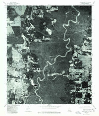
1976 Map of Bogalusa SE
USGS Topo · Published 1977About this map
Bogalusa and its surrounding riverine landscape are documented in this mid-1970s orthophoto, which uses aerial imagery to show the physical footprint of the city alongside the natural world. The eastern half of the map is dominated by the winding course of the Pearl River, which serves as the boundary between Louisiana and Mississippi. The tight, serpentine meanders of the river channel suggest a low-lying floodplain, where oxbows and swampy depressions are visible through the dense tree cover. In contrast to the heavy vegetation of the river bottomlands, the developed areas of Bogalusa appear as a clear grid of streets and industrial sites, providing a direct visual comparison between the town's expansion and the persistent wilderness of the Pearl River basin.
Find a feature on this map
2 named features on this map. Tap any name to fly to it.
Don’t see what you’re looking for? This feature index may not catch every label — zoom into the map to look around manually.
Map Details
Editions of this 1976 Bogalusa SE Map
This is the sole edition of this map. No revisions or reprints were ever made.
Other maps of this area

1942 · Rio
USGS Topo · 1:31,680

1942 · Pools Bluff
USGS Topo · 1:31,680

1949 · Bogalusa East
USGS Topo · 1:31,680

1949 · Angie
USGS Topo · 1:31,680

1949 · Bogalusa West
USGS Topo · 1:31,680

1950 · Crains Creek
USGS Topo · 1:31,680

1953 · Mobile
USGS Topo · 1:250,000

1957 · Mobile
USGS Topo · 1:250,000

1958 · Picayune
USGS Topo · 1:62,500

1959 · Bogalusa
USGS Topo · 1:62,500