1930s Maps of Falcon, Mississippi
Explore 6 historic maps of Falcon from the 1930s. These maps offer a rare glimpse into what life looked like during the 1930s — showing old roads, neighborhoods, homes, and landmarks that have changed or disappeared over time.
Whether you're researching your family's past, planning a metal detecting trip, or studying how Falcon's landscape evolved across the 1930s, these high-resolution maps are a powerful tool for exploring the history of this region.
- Focus on a specific era: All maps on this page are from the 1930s, giving you a focused view of this time period.
- See what’s changed: Compare century-old streets, trails, and buildings to today's modern landscape using overlays and satellite layers.
- Research with precision: Use these maps for genealogy, historical research, land use analysis, or educational projects.
- View, download, or print: Maps are fully viewable online in high resolution, and can be downloaded or printed for your own records.
Start exploring Falcon's history through authentic maps from the 1930s. This is your window into the past.
Falcon, MS maps
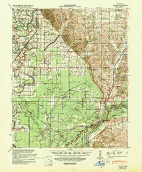
(6)- 1932 Map of Sledge
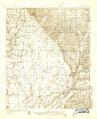 1932 Sledge1932 Print · USGSThe Mississippi Delta's complex water and rail networks are preserved here as they existed in the early thirties. Genealogists and local historians can trace family locations near the Yazoo and Mississippi Valley RR, Porters Ferry Sch, and Sanfords Chapel.2 unique versions available
 - 1932 Map of Marks
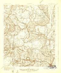 1932 Marks1932 Print · USGSThe Mississippi Delta in the early 1930s is a landscape of complex bayous and tight-knit rural communities. Genealogists can trace family roots through numerous local landmarks like Swan Lake Normal College, Robinson Chapel, and the Yazoo and Mississippi Valley Railroad.2 unique versions available
 - 1935 Map of Marks
 1935 Marks1935 Print · USGSThe Mississippi Delta landscape of the 1930s is captured here in rich detail, showcasing a network of bayous and rail towns. Genealogists can locate family landmarks like Swan Lake College, Macedonia Chapel, and the Posey Mound near Jonestown.2 unique versions available
 - 1935 Map of Sledge
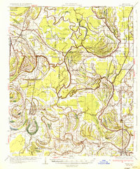
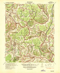
 1935 Sledge1935 Print · USGSThe Tallahatchie River bottomlands come to life in this mid-1930s survey of the Quitman and Panola county line. Genealogists and local historians can trace the foundations of rural life through family-named landmarks like Harmonious Sch, the railroad hub at Sledge, and Carnes Landing Field.2 unique versions available
 - 1939 Map of Sledge, 1943 Print
 1939 Sledge1943 Print · USGSThe Mississippi Delta's intricate river and rail network comes to life in this late 1930s survey of the Sledge and Batesville area. Genealogists can trace family footprints across dozens of country landmarks like Curtis Station, Mastodon Sch, and Porters Ferry.
 - 1939 Map of Marks, 1943 Print
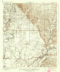
 1939 Marks1943 Print · USGSThe Mississippi Delta era is preserved here just before the war, showing a landscape defined by the Coldwater River and the Yazoo and Mississippi Valley RR. Genealogists can trace local roots at Swan Lake College, Belen, and Strangers Rest Ch.
End of results
Showing maps 1-6 of 6
Top cities near Falcon
- Marks historical maps
- Lambert historical maps
- Jonestown historical maps
- Sledge historical maps
- Lula historical maps
Frequently asked questions
- What are the different types of historical maps available for Falcon?
- What is the oldest map of Falcon?
- Where can I purchase historical maps of Falcon for my home or office?
- Where can I download high-res historical maps of Falcon?
- Are there historical topographic maps available for Falcon?
- Is there historical aerial imagery available for Falcon?
- Where are historical maps of Falcon sourced from?