1960s Maps of West Marks, Mississippi
Explore 2 historic maps of West Marks from the 1960s. These maps offer a rare glimpse into what life looked like during the 1960s — showing old roads, neighborhoods, homes, and landmarks that have changed or disappeared over time.
Whether you're researching your family's past, planning a metal detecting trip, or studying how West Marks's landscape evolved across the 1960s, these high-resolution maps are a powerful tool for exploring the history of this region.
- Focus on a specific era: All maps on this page are from the 1960s, giving you a focused view of this time period.
- See what’s changed: Compare century-old streets, trails, and buildings to today's modern landscape using overlays and satellite layers.
- Research with precision: Use these maps for genealogy, historical research, land use analysis, or educational projects.
- View, download, or print: Maps are fully viewable online in high resolution, and can be downloaded or printed for your own records.
Start exploring West Marks's history through authentic maps from the 1960s. This is your window into the past.
West Marks, MS maps
(2)- 1960 Map of Helena
 1960 Helena1960 Print · USGSThe Arkansas and Mississippi Delta regions meet along the great river bends during a period of significant agricultural and rail expansion. Genealogists and historians can trace the paths of the Missouri Pacific railroad through Clarendon or locate landings along the Mississippi River and White River.
 - 1969 Map of Marks, 1971 Print
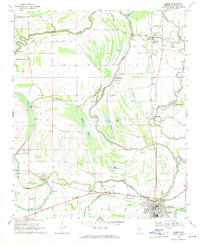 1969 Marks1971 Print · USGSThe Quitman County Delta in the late sixties reveals a landscape shaped by ancient earthworks and the steady flow of the Coldwater River. Genealogists can trace family names at Gleason Grove Cem or locate historic congregations like Macedonia Ch and Belview Ch.
End of results
Showing maps 1-2 of 2
Top cities near West Marks
- Clarksdale historical maps
- Marks historical maps
- Lambert historical maps
- Jonestown historical maps
- Sledge historical maps
- Coahoma historical maps
See more
Frequently asked questions
- What are the different types of historical maps available for West Marks?
- What is the oldest map of West Marks?
- Where can I purchase historical maps of West Marks for my home or office?
- Where can I download high-res historical maps of West Marks?
- Are there historical topographic maps available for West Marks?
- Is there historical aerial imagery available for West Marks?
- Where are historical maps of West Marks sourced from?