1980s Maps of McLaurin Heights, Pearl
Explore 2 historic maps of McLaurin Heights from the 1980s. These maps offer a rare glimpse into what life looked like during the 1980s — showing old roads, neighborhoods, homes, and landmarks that have changed or disappeared over time.
Whether you're researching your family's past, planning a metal detecting trip, or studying how McLaurin Heights's landscape evolved across the 1980s, these high-resolution maps are a powerful tool for exploring the history of this region.
- Focus on a specific era: All maps on this page are from the 1980s, giving you a focused view of this time period.
- See what’s changed: Compare century-old streets, trails, and buildings to today's modern landscape using overlays and satellite layers.
- Research with precision: Use these maps for genealogy, historical research, land use analysis, or educational projects.
- View, download, or print: Maps are fully viewable online in high resolution, and can be downloaded or printed for your own records.
Start exploring McLaurin Heights's history through authentic maps from the 1980s. This is your window into the past.
McLaurin Heights, Pearl maps
(2)- 1980 Map of Jackson SE
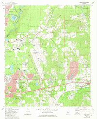 1980 Jackson SE1980 Print · USGSRankin County enters a period of modern expansion in the 1980s, where traditional settlements meet the growing infrastructure of the Pearl River corridor. Researchers can trace family sites at Drakes Ch, Flora Hills Cem, and the neighborhoods of McLaurin Heights.2 unique versions available
 - 1984 Map of Jackson
 1984 Jackson1984 Print · USGSCentral Mississippi in the mid-eighties shows a landscape defined by the growing suburbs of Jackson and the riverfront legacy of Vicksburg. Researchers can trace the Natchez Trace Parkway or locate local landmarks like Utica College and Mississippi State Hospital.
End of results
Showing maps 1-2 of 2
Frequently asked questions
- What are the different types of historical maps available for McLaurin Heights?
- What is the oldest map of McLaurin Heights?
- Where can I purchase historical maps of McLaurin Heights for my home or office?
- Where can I download high-res historical maps of McLaurin Heights?
- Are there historical topographic maps available for McLaurin Heights?
- Is there historical aerial imagery available for McLaurin Heights?
- Where are historical maps of McLaurin Heights sourced from?