1980s Maps of Effie, Mississippi
Explore 2 historic maps of Effie from the 1980s. These maps offer a rare glimpse into what life looked like during the 1980s — showing old roads, neighborhoods, homes, and landmarks that have changed or disappeared over time.
Whether you're researching your family's past, planning a metal detecting trip, or studying how Effie's landscape evolved across the 1980s, these high-resolution maps are a powerful tool for exploring the history of this region.
- Focus on a specific era: All maps on this page are from the 1980s, giving you a focused view of this time period.
- See what’s changed: Compare century-old streets, trails, and buildings to today's modern landscape using overlays and satellite layers.
- Research with precision: Use these maps for genealogy, historical research, land use analysis, or educational projects.
- View, download, or print: Maps are fully viewable online in high resolution, and can be downloaded or printed for your own records.
Start exploring Effie's history through authentic maps from the 1980s. This is your window into the past.
Effie, MS maps
(2)- 1981 Map of Tippo, 1982 Print
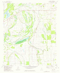 1981 Tippo1982 Print · USGSThe Mississippi Delta's intricate river systems and rural settlements are captured here in the early eighties. Genealogists and historians can locate family landmarks such as Rabbit Ridge Plantation, Needmore Cem, and Locopolis Ch among the oxbow lakes.
 - 1983 Map of Greenwood
 1983 Greenwood1983 Print · USGSThe Mississippi Delta in the early eighties shows a landscape of rail-connected towns and vast river systems. Genealogists and historians can trace family roots in towns like Mound Bayou, Ruleville, and the grounds of Mississippi Valley State University.
End of results
Showing maps 1-2 of 2
Top cities near Effie
Frequently asked questions
- What are the different types of historical maps available for Effie?
- What is the oldest map of Effie?
- Where can I purchase historical maps of Effie for my home or office?
- Where can I download high-res historical maps of Effie?
- Are there historical topographic maps available for Effie?
- Is there historical aerial imagery available for Effie?
- Where are historical maps of Effie sourced from?