Old Maps of Tallahatchie County, Mississippi
Explore 176 old maps of Tallahatchie County, spanning from 1931 to today. These high-resolution historic maps reveal how streets, neighborhoods, landmarks, and natural features evolved over time — perfect for genealogy, metal detecting, research, and local history exploration.
What you can do with these maps:
- See how Tallahatchie County changed over time: Compare historical maps to modern-day views to trace roads, homesites, rail lines & more.
- View detailed metadata: Each map includes creators, publishers, year, scale, and archive source.
- Overlay maps with satellite & LiDAR: Visualize the past alongside modern tools to explore terrain & human change.
- Trusted historical sources: Maps sourced from the USGS, Library of Congress, and other archives.
- Access maps your way: View online, download high-res files, or order prints for personal or research use.
Start exploring old maps of Tallahatchie County to uncover forgotten places, hidden landmarks, and the deep history beneath your feet.
Tallahatchie County, MS maps
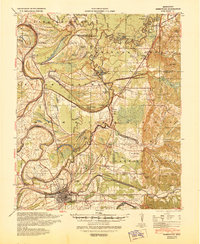
(176)- 1931 Map of Schlater
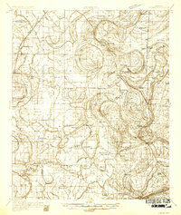
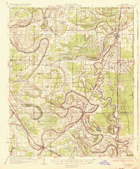
 1931 Schlater1931 Print · USGSThe Mississippi Delta's complex network of bayous and winding river bends is captured in the early 1930s. Genealogists can trace hundreds of family and community landmarks, from the Rosenwald Sch to small congregations like Thankful Ch and Harts Chapel.
 - 1931 Map of Sumner
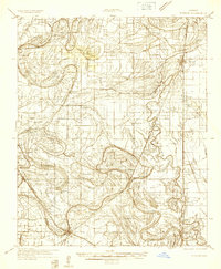
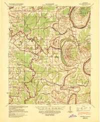
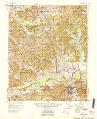
 1931 Sumner1931 Print · USGSTallahatchie County in the early thirties is captured here as a landscape of cotton fields and bayous connected by the Yazoo and Mississippi Valley Railroad. Researchers can locate community centers like Glendora and Sumner, or trace family ties to the Brooks-Rosenwald Sch and Indian Mounds.4 unique versions available
 - 1932 Map of Philipp
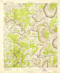
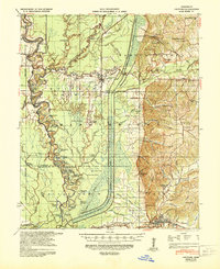
 1932 Philipp1932 Print · USGSTallahatchie and Grenada counties in the early 1930s show a landscape shaped by river bends and the expansion of the rail network. Genealogists can trace family roots through numerous country schools and churches like Cowart Sch, Rosenwald Sch, and Jorden Hill Cem.4 unique versions available
 - 1932 Map of Tutwiler
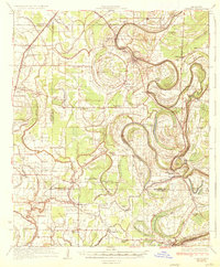
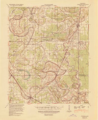
 1932 Tutwiler1932 Print · USGSTallahatchie County was a landscape of winding oxbows and rail-linked settlements in the early 1930s. Genealogists and historians can trace numerous rural congregations like Whitfield Ch and New Bethlehem Ch, alongside industry at Fitches Gin.
 - 1934 Map of Schlater
 1934 Schlater1934 Print · USGSThe Mississippi Delta's winding bayous and rail towns are captured here in the early 1930s, showing a landscape of intense riverfront settlement. Genealogists can trace family-named sites across the floodplains, from Schlater and Sunnyside to the Rosenwald Sch and Rock of Ages Ch.2 unique versions available
 - 1935 Map of Crowder
 1935 Crowder1935 Print · USGSThe Mississippi Delta's intricate river systems and rural communities are captured here in the mid-1930s. Researchers can locate vanished landmarks like Dry Bayou Plantation, the Quitman Co Hunting Club, and numerous schools such as Pharsalia Sch.3 unique versions available
 - 1935 Map of Sumner
 1935 Sumner1935 Print · USGSThe Mississippi Delta's intricate river bends and rail towns are captured here in the mid-1930s. Family historians can trace numerous rural sites like Brooks Rosenwald Sch, the State Reservation at Parchman, and the town of Glendora.2 unique versions available
 - 1935 Map of Tutwiler
 1935 Tutwiler1935 Print · USGSThe Mississippi Delta in the 1930s was a landscape defined by the winding Cassidy Bayou and the railroads that sustained its cotton towns. Genealogists can trace the rural communities of Tutwiler and Lambert, or locate local landmarks like Mud Bridge and Holly Grove Ch.2 unique versions available
 - 1935 Map of Philipp
 1935 Philipp1935 Print · USGSThe Mississippi Delta meets the bluff hills in the 1930s, revealing a landscape of winding bayous and railroad-line settlements. Genealogists can locate family landmarks like the Rosenwald Sch, Paynes Cem, and the river town of Locopolis.2 unique versions available
 - 1936 Map of Greenwood
 1936 Greenwood1936 Print · USGSThe Mississippi Delta's river-driven economy is on full display in the mid-1930s as the forks of the Yazoo converge at Greenwood. Genealogists and historians can locate rural landmarks like Geren PO, Little Zion Ch, and the Rosenwald Sch among the oxbows of Tippo Bayou.2 unique versions available
 - 1939 Map of Schlater, 1941 Print
 1939 Schlater1941 Print · USGSThe Mississippi Delta's intricate network of bayous and agricultural communities is captured here in the late 1930s. Genealogists can trace family roots through numerous local landmarks like Rosenwald Sch, Mile Tabernacle, and Rock of Ages Ch.
 - 1939 Map of Sumner, 1943 Print
 1939 Sumner1943 Print · USGSTallahatchie County in the late thirties is a landscape of winding river bends and Delta rail towns like Sumner and Glendora. Genealogists and historians can trace numerous rural landmarks, including the Brooks Rosenwald Sch and the ancient Indian Mounds.
 - 1939 Map of Crowder, 1943 Print
 1939 Crowder1943 Print · USGSThe Delta lowlands near the Panola and Quitman border are captured here during a period of transition in water management. Researchers can locate vanished rural landmarks like Independence Sch, Oak Grove Ch, and the Quitman Co Hunting Club.
 - 1939 Map of Philipp, 1943 Print
 1939 Philipp1943 Print · USGSThe Tallahatchie River Delta is captured here in the decade before major postwar transformation, showing a landscape defined by bayous and small rural hubs. Local researchers can trace family roots through numerous churches and schools like St Mark Ch, Jones Chapel Sch, and the Tallahat Boy Scout Camp.
 - 1939 Map of Tutwiler, 1943 Print
 1939 Tutwiler1943 Print · USGSNorthwestern Mississippi in the 1930s shows a landscape defined by meandering bayous and the cotton economy of the Delta. Genealogists and historians can trace numerous small communities like Tutwiler and Vance, alongside rural landmarks like St Elmo Chapel and State Farm Camp B.
 - 1940 Map of Greenwood, 1945 Print
 1940 Greenwood1945 Print · USGSThe Mississippi Delta's river-and-rail economy is in full view at the start of the 1940s, where the Yazoo River begins. Genealogists and historians can trace rural communities through the Rosenwald Sch, Ruby Sta, and the historic Malmaison estate.
 - 1948 Map of Helena
 1948 Helena1948 Print · USGSEastern Arkansas and the Mississippi Delta are captured here just after the war, showing a landscape defined by its great rivers and rail lines. Genealogists can trace family locations near Bemis Plantation, Helena, and smaller rail stops like Wheatley and Moro.
 - 1950 Map of Helena
 1950 Helena1950 Print · USGSMid-century Phillips County and the surrounding Delta region are shown at a peak of rail and river commerce. Genealogists and historians can trace family locations through numerous rural communities like Old Austin, Cotton Plant, and West Helena, or follow the routes of the Missouri Pacific RR across Grand Prairie.2 unique versions available
 - 1953 Map of Greenwood, 1966 Print
 1953 Greenwood1966 Print · USGSThe Mississippi Delta in the mid-fifties is captured here as a thriving network of river towns, railroads, and oxbow lakes. Researchers can trace the legacy of the Illinois Central Railroad and locate landmarks like the State Penal Farm and Greenville Air Force Base.5 unique versions available
 - 1953 Map of West Point, 1973 Print
 1953 West Point1973 Print · USGSNorth-Central Mississippi and the Alabama borderlands are captured here during the mid-twentieth century as new reservoirs and national forests transformed the landscape. Researchers can trace the path of the Mississippi & Skuna Valley railroad or locate old landings along the Tombigbee River and Schooner Creek.3 unique versions available
 - 1954 Map of Grenada
 1954 Grenada1954 Print · USGSGrenada and the surrounding hills are captured here just as the river valley was transformed by the reservoir. Genealogists can locate family sites like Preston Sch & Ch, Barksdale Cem, and the railroad community of Dubard.2 unique versions available
 - 1954 Map of Oakland
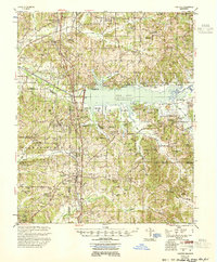 1954 Oakland1954 Print · USGSThe Enid Lake area and the Yocona River valley are captured in the mid-1950s as flood control projects reshaped the Mississippi landscape. Researchers can trace rural lineages through dozens of sites like Mount Pisgah Ch & Cem and Spring Hill Sch & Cem.3 unique versions available
 - 1955 Map of Helena, 1967 Print
 1955 Helena1967 Print · USGSThe Arkansas Delta and Mississippi floodplains are captured here in the mid-fifties, during a period of expanding flood control and rail commerce. Researchers can trace the extensive Chicago Rock Island and Pacific RR lines and locate sites like the Arkansas State College Experimental Rice Farm or Friars Point.2 unique versions available
 - 1956 Map of Greenwood
 1956 Greenwood1956 Print · USGSThe Mississippi Delta in the mid-fifties is captured here during a period of significant military and agricultural activity. Researchers can trace the rail lines of the Illinois Central RR, find the Greenville Air Force Base, or locate the State Penal Farm.
 - 1956 Map of Tupelo, 1967 Print
 1956 Tupelo1967 Print · USGSNortheast Mississippi and parts of Tennessee and Alabama are shown here during the mid-fifties, a time of major reservoir construction and forestry management. Researchers can trace the St Louis-San Francisco RR through Tupelo or locate historic sites like Tishomingo State Park and the University.2 unique versions available
Showing maps 1-25 of 176
Top cities of Tallahatchie County
- Charleston historical maps
- Tutwiler historical maps
- Webb historical maps
- Sumner historical maps
- Glendora historical maps
Frequently asked questions
- What are the different types of historical maps available for Tallahatchie County?
- What is the oldest map of Tallahatchie County?
- Where can I purchase historical maps of Tallahatchie County for my home or office?
- Where can I download high-res historical maps of Tallahatchie County?
- Are there historical topographic maps available for Tallahatchie County?
- Is there historical aerial imagery available for Tallahatchie County?
- Where are historical maps of Tallahatchie County sourced from?